You are here: Home > Network List > TA - USArray Transportable Network (new EarthScope stations) Stations List
> Station K61A Williamstown, MA, USA > Earthquake Result Viewer
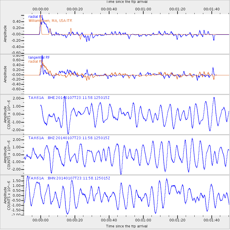
K61A Williamstown, MA, USA - Earthquake Result Viewer
*The percent match for this event was below the threshold and hence no stack was calculated.
| Earthquake location: |
Central East Pacific Rise |
| Earthquake latitude/longitude: |
-4.5/-106.1 |
| Earthquake time(UTC): |
2014/01/07 (007) 23:02:53 GMT |
| Earthquake Depth: |
10 km |
| Earthquake Magnitude: |
5.7 MWB, 5.8 MWC |
| Earthquake Catalog/Contributor: |
NEIC PDE/NEIC COMCAT |
|
| Network: |
TA USArray Transportable Network (new EarthScope stations) |
| Station: |
K61A Williamstown, MA, USA |
| Lat/Lon: |
42.67 N/73.27 W |
| Elevation: |
391 m |
|
| Distance: |
55.6 deg |
| Az: |
28.966 deg |
| Baz: |
220.89 deg |
| Ray Param: |
$rayparam |
*The percent match for this event was below the threshold and hence was not used in the summary stack. |
|
| Radial Match: |
45.729115 % |
| Radial Bump: |
400 |
| Transverse Match: |
67.31404 % |
| Transverse Bump: |
400 |
| SOD ConfigId: |
3390531 |
| Insert Time: |
2019-04-09 22:18:47.716 +0000 |
| GWidth: |
2.5 |
| Max Bumps: |
400 |
| Tol: |
0.001 |
|
Signal To Noise
| Channel | StoN | STA | LTA |
| TA:K61A: :BHZ:20140107T23:11:58.125015Z | 0.7120907 | 7.176274E-7 | 1.0077754E-6 |
| TA:K61A: :BHN:20140107T23:11:58.125015Z | 0.84143376 | 7.877716E-7 | 9.362254E-7 |
| TA:K61A: :BHE:20140107T23:11:58.125015Z | 1.1962359 | 1.0835155E-6 | 9.057707E-7 |
| Arrivals |
| Ps | |
| PpPs | |
| PsPs/PpSs | |


