You are here: Home > Network List > AK - Alaska Regional Network Stations List
> Station KIAG Kiagna River, AK, USA > Earthquake Result Viewer
KIAG Kiagna River, AK, USA - Earthquake Result Viewer
| Earthquake location: |
Tajikistan-Xinjiang Border Reg. |
| Earthquake latitude/longitude: |
38.1/73.2 |
| Earthquake time(UTC): |
2023/02/23 (054) 00:37:40 GMT |
| Earthquake Depth: |
21 km |
| Earthquake Magnitude: |
6.8 Mww |
| Earthquake Catalog/Contributor: |
NEIC PDE/us |
|
| Network: |
AK Alaska Regional Network |
| Station: |
KIAG Kiagna River, AK, USA |
| Lat/Lon: |
60.92 N/142.36 W |
| Elevation: |
1773 m |
|
| Distance: |
77.2 deg |
| Az: |
16.943 deg |
| Baz: |
331.91 deg |
| Ray Param: |
0.05049203 |
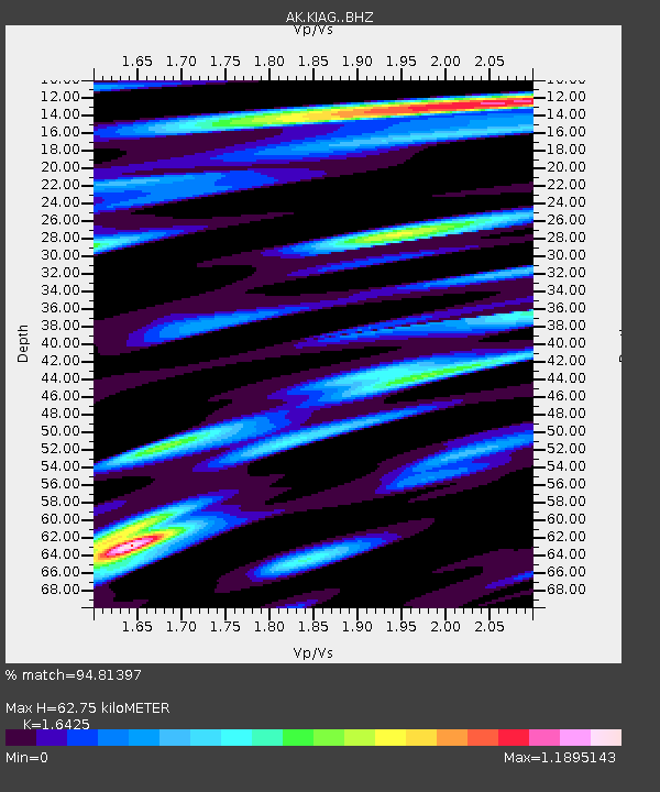
| Estimated Moho Depth: |
62.75 km |
| Estimated Crust Vp/Vs: |
1.64 |
| Assumed Crust Vp: |
6.566 km/s |
| Estimated Crust Vs: |
3.998 km/s |
| Estimated Crust Poisson's Ratio: |
0.21 |
|
| Radial Match: |
94.81397 % |
| Radial Bump: |
400 |
| Transverse Match: |
81.87866 % |
| Transverse Bump: |
400 |
| SOD ConfigId: |
34243671 |
| Insert Time: |
2024-05-03 01:14:55.543 +0000 |
| GWidth: |
2.5 |
| Max Bumps: |
400 |
| Tol: |
0.001 |
|

Signal To Noise
| Channel | StoN | STA | LTA |
| AK:KIAG: :BHZ:20230223T00:49:00.808011Z | 24.5193 | 3.319327E-6 | 1.353761E-7 |
| AK:KIAG: :BHN:20230223T00:49:00.808011Z | 8.569185 | 1.0658388E-6 | 1.243804E-7 |
| AK:KIAG: :BHE:20230223T00:49:00.808011Z | 5.2409525 | 8.439348E-7 | 1.6102699E-7 |
| Arrivals |
| Ps | 6.4 SECOND |
| PpPs | 24 SECOND |
| PsPs/PpSs | 31 SECOND |


