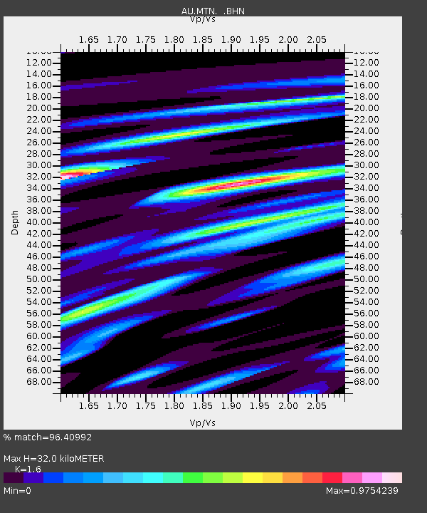
MTN Manton Dam, Northern Territory - Earthquake Result Viewer

Earthquake location: Southern Sumatra, Indonesia
Earthquake latitude/longitude: -3.5/100.1
Earthquake time(UTC): 2010/10/25 (298) 14:42:22 GMT
Earthquake Depth: 20 km
Earthquake Magnitude: 6.5 MB, 7.3 MS, 7.8 MW, 7.7 MW
Earthquake Catalog/Contributor: WHDF/NEIC
Network: AU Australian Seismological Centre
Station: MTN Manton Dam, Northern Territory
Lat/Lon: 12.84 S/131.13 E
Elevation: 137 m
Distance: 32.1 deg
Az: 108.671 deg
Baz: 284.166 deg
Ray Param: 0.07878689
Estimated Moho Depth: 32.0 km
Estimated Crust Vp/Vs: 1.60
Assumed Crust Vp: 6.61 km/s
Estimated Crust Vs: 4.131 km/s
Estimated Crust Poisson's Ratio: 0.18
Radial Match: 96.40992 %
Radial Bump: 400
Transverse Match: 86.26827 %
Transverse Bump: 400
SOD ConfigId: 339645
Insert Time: 2011-02-24 08:24:43.958 +0000
GWidth: 2.5
Max Bumps: 400
Tol: 0.001

Signal To Noise

ChannelStoNSTALTA
AU:MTN: :BHZ:20101025T14:48:17.34501Z20.4841982.216505E-61.082056E-7
AU:MTN: :BHN:20101025T14:48:17.34501Z5.7330784.920884E-78.583319E-8
AU:MTN: :BHE:20101025T14:48:17.34501Z9.2342941.4237801E-61.5418397E-7
Arrivals
Ps3.2 SECOND
PpPs11 SECOND
PsPs/PpSs15 SECOND