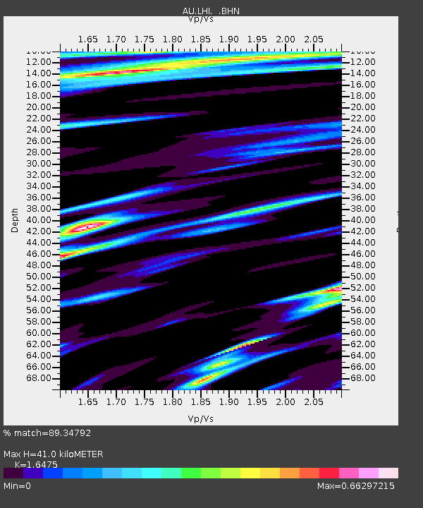
LHI Lord Howe Island, Australia - Earthquake Result Viewer

Earthquake location: Southern Sumatra, Indonesia
Earthquake latitude/longitude: -3.5/100.1
Earthquake time(UTC): 2010/10/25 (298) 14:42:22 GMT
Earthquake Depth: 20 km
Earthquake Magnitude: 6.5 MB, 7.3 MS, 7.8 MW, 7.7 MW
Earthquake Catalog/Contributor: WHDF/NEIC
Network: AU Australian Seismological Centre
Station: LHI Lord Howe Island, Australia
Lat/Lon: 31.52 S/159.06 E
Elevation: 74 m
Distance: 61.9 deg
Az: 123.949 deg
Baz: 284.173 deg
Ray Param: 0.06054761
Estimated Moho Depth: 41.0 km
Estimated Crust Vp/Vs: 1.65
Assumed Crust Vp: 4.157 km/s
Estimated Crust Vs: 2.523 km/s
Estimated Crust Poisson's Ratio: 0.21
Radial Match: 89.34792 %
Radial Bump: 351
Transverse Match: 73.74043 %
Transverse Bump: 400
SOD ConfigId: 339645
Insert Time: 2011-02-24 08:24:48.826 +0000
GWidth: 2.5
Max Bumps: 400
Tol: 0.001

Signal To Noise

ChannelStoNSTALTA
AU:LHI: :BHZ:20101025T14:52:09.519998Z2.37478951.3721344E-65.7779204E-7
AU:LHI: :BHN:20101025T14:52:09.519998Z1.01836565.4865745E-75.387628E-7
AU:LHI: :BHE:20101025T14:52:09.519998Z1.57545459.3155126E-75.9129053E-7
Arrivals
Ps6.5 SECOND
PpPs26 SECOND
PsPs/PpSs32 SECOND