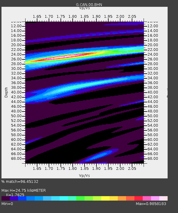
CAN Canberra, Australia - Earthquake Result Viewer

Earthquake location: Southern Sumatra, Indonesia
Earthquake latitude/longitude: -3.5/100.1
Earthquake time(UTC): 2010/10/25 (298) 14:42:22 GMT
Earthquake Depth: 20 km
Earthquake Magnitude: 6.5 MB, 7.3 MS, 7.8 MW, 7.7 MW
Earthquake Catalog/Contributor: WHDF/NEIC
Network: G GEOSCOPE
Station: CAN Canberra, Australia
Lat/Lon: 35.32 S/149.00 E
Elevation: 650 m
Distance: 55.2 deg
Az: 131.329 deg
Baz: 293.564 deg
Ray Param: 0.06494724
Estimated Moho Depth: 24.75 km
Estimated Crust Vp/Vs: 1.76
Assumed Crust Vp: 6.633 km/s
Estimated Crust Vs: 3.764 km/s
Estimated Crust Poisson's Ratio: 0.26
Radial Match: 96.45132 %
Radial Bump: 242
Transverse Match: 89.71639 %
Transverse Bump: 327
SOD ConfigId: 339645
Insert Time: 2011-02-24 08:25:59.516 +0000
GWidth: 2.5
Max Bumps: 400
Tol: 0.001

Signal To Noise

ChannelStoNSTALTA
G:CAN:00:BHZ:20101025T14:51:22.569985Z5.37071851.165447E-62.170002E-7
G:CAN:00:BHN:20101025T14:51:22.569985Z1.12250962.544495E-72.2667913E-7
G:CAN:00:BHE:20101025T14:51:22.569985Z2.80046654.8134524E-71.7188037E-7
Arrivals
Ps3.0 SECOND
PpPs9.7 SECOND
PsPs/PpSs13 SECOND