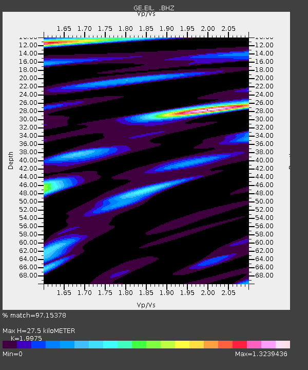
EIL GEOFON Station Eilat, Israel - Earthquake Result Viewer

Earthquake location: Southern Sumatra, Indonesia
Earthquake latitude/longitude: -3.5/100.1
Earthquake time(UTC): 2010/10/25 (298) 14:42:22 GMT
Earthquake Depth: 20 km
Earthquake Magnitude: 6.5 MB, 7.3 MS, 7.8 MW, 7.7 MW
Earthquake Catalog/Contributor: WHDF/NEIC
Network: GE GEOFON
Station: EIL GEOFON Station Eilat, Israel
Lat/Lon: 29.67 N/34.95 E
Elevation: 210 m
Distance: 70.4 deg
Az: 303.047 deg
Baz: 105.979 deg
Ray Param: 0.05499323
Estimated Moho Depth: 27.5 km
Estimated Crust Vp/Vs: 2.00
Assumed Crust Vp: 6.472 km/s
Estimated Crust Vs: 3.24 km/s
Estimated Crust Poisson's Ratio: 0.33
Radial Match: 97.15378 %
Radial Bump: 400
Transverse Match: 90.344154 %
Transverse Bump: 400
SOD ConfigId: 339645
Insert Time: 2011-02-24 08:26:19.119 +0000
GWidth: 2.5
Max Bumps: 400
Tol: 0.001

Signal To Noise

ChannelStoNSTALTA
GE:EIL: :BHZ:20101025T14:53:03.800027Z5.22469854.5918964E-78.788825E-8
GE:EIL: :BHN:20101025T14:53:03.800027Z1.24390466.258345E-85.03121E-8
GE:EIL: :BHE:20101025T14:53:03.800027Z2.40670871.9527316E-78.113702E-8
Arrivals
Ps4.4 SECOND
PpPs12 SECOND
PsPs/PpSs17 SECOND