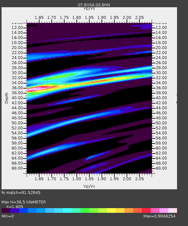
BOSA Boshof, South Africa - Earthquake Result Viewer
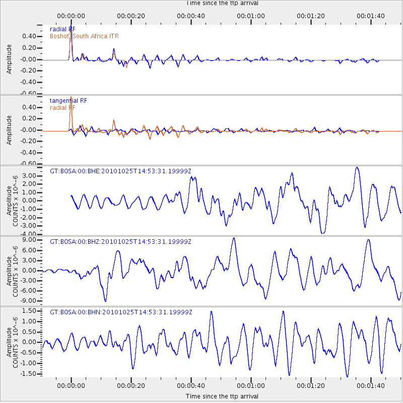
Earthquake location: Southern Sumatra, Indonesia
Earthquake latitude/longitude: -3.5/100.1
Earthquake time(UTC): 2010/10/25 (298) 14:42:22 GMT
Earthquake Depth: 20 km
Earthquake Magnitude: 6.5 MB, 7.3 MS, 7.8 MW, 7.7 MW
Earthquake Catalog/Contributor: WHDF/NEIC
Network: GT Global Telemetered Seismograph Network (USAF/USGS)
Station: BOSA Boshof, South Africa
Lat/Lon: 28.61 S/25.26 E
Elevation: 1280 m
Distance: 75.0 deg
Az: 241.452 deg
Baz: 85.764 deg
Ray Param: 0.051925674
Estimated Moho Depth: 36.5 km
Estimated Crust Vp/Vs: 1.61
Assumed Crust Vp: 6.459 km/s
Estimated Crust Vs: 4.025 km/s
Estimated Crust Poisson's Ratio: 0.18
Radial Match: 91.52945 %
Radial Bump: 282
Transverse Match: 74.761055 %
Transverse Bump: 400
SOD ConfigId: 339645
Insert Time: 2011-02-24 08:26:33.381 +0000
GWidth: 2.5
Max Bumps: 400
Tol: 0.001

Signal To Noise

ChannelStoNSTALTA
GT:BOSA:00:BHZ:20101025T14:53:31.19999Z1.75176141.0935196E-66.2424004E-7
GT:BOSA:00:BHN:20101025T14:53:31.19999Z0.70328772.8255042E-74.017565E-7
GT:BOSA:00:BHE:20101025T14:53:31.19999Z1.08577785.513792E-75.078195E-7
Arrivals
Ps3.5 SECOND
PpPs14 SECOND
PsPs/PpSs18 SECOND