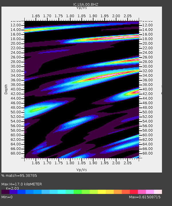
LSA Tibet, China - Earthquake Result Viewer
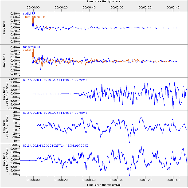
Earthquake location: Southern Sumatra, Indonesia
Earthquake latitude/longitude: -3.5/100.1
Earthquake time(UTC): 2010/10/25 (298) 14:42:22 GMT
Earthquake Depth: 20 km
Earthquake Magnitude: 6.5 MB, 7.3 MS, 7.8 MW, 7.7 MW
Earthquake Catalog/Contributor: WHDF/NEIC
Network: IC New China Digital Seismograph Network
Station: LSA Tibet, China
Lat/Lon: 29.70 N/91.13 E
Elevation: 3660 m
Distance: 34.1 deg
Az: 346.021 deg
Baz: 163.91 deg
Ray Param: 0.07788192
Estimated Moho Depth: 17.0 km
Estimated Crust Vp/Vs: 2.03
Assumed Crust Vp: 6.514 km/s
Estimated Crust Vs: 3.209 km/s
Estimated Crust Poisson's Ratio: 0.34
Radial Match: 95.38785 %
Radial Bump: 400
Transverse Match: 83.91095 %
Transverse Bump: 400
SOD ConfigId: 339645
Insert Time: 2011-02-24 08:26:43.614 +0000
GWidth: 2.5
Max Bumps: 400
Tol: 0.001

Signal To Noise

ChannelStoNSTALTA
IC:LSA:00:BHZ:20101025T14:48:34.997994Z15.9527193.4038815E-62.1337313E-7
IC:LSA:00:BHN:20101025T14:48:34.997994Z23.1432481.1609835E-65.0165106E-8
IC:LSA:00:BHE:20101025T14:48:34.997994Z5.5864626.6256456E-71.18601825E-7
Arrivals
Ps2.9 SECOND
PpPs7.4 SECOND
PsPs/PpSs10 SECOND