You are here: Home > Network List > II - Global Seismograph Network (GSN - IRIS/IDA) Stations List
> Station MBAR Mbarara, Uganda > Earthquake Result Viewer
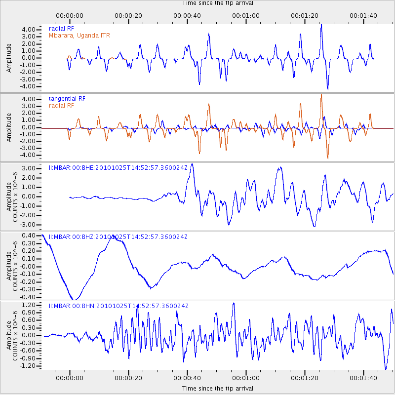
MBAR Mbarara, Uganda - Earthquake Result Viewer
*The percent match for this event was below the threshold and hence no stack was calculated.
| Earthquake location: |
Southern Sumatra, Indonesia |
| Earthquake latitude/longitude: |
-3.5/100.1 |
| Earthquake time(UTC): |
2010/10/25 (298) 14:42:22 GMT |
| Earthquake Depth: |
20 km |
| Earthquake Magnitude: |
6.5 MB, 7.3 MS, 7.8 MW, 7.7 MW |
| Earthquake Catalog/Contributor: |
WHDF/NEIC |
|
| Network: |
II Global Seismograph Network (GSN - IRIS/IDA) |
| Station: |
MBAR Mbarara, Uganda |
| Lat/Lon: |
0.60 S/30.74 E |
| Elevation: |
1390 m |
|
| Distance: |
69.3 deg |
| Az: |
270.667 deg |
| Baz: |
93.476 deg |
| Ray Param: |
$rayparam |
*The percent match for this event was below the threshold and hence was not used in the summary stack. |
|
| Radial Match: |
43.145992 % |
| Radial Bump: |
400 |
| Transverse Match: |
35.939148 % |
| Transverse Bump: |
400 |
| SOD ConfigId: |
339645 |
| Insert Time: |
2011-02-24 08:26:52.266 +0000 |
| GWidth: |
2.5 |
| Max Bumps: |
400 |
| Tol: |
0.001 |
|
Signal To Noise
| Channel | StoN | STA | LTA |
| II:MBAR:00:BHZ:20101025T14:52:57.360024Z | 0.83647305 | 2.970551E-7 | 3.5512812E-7 |
| II:MBAR:00:BHN:20101025T14:52:57.360024Z | 2.415486 | 1.0654146E-7 | 4.410767E-8 |
| II:MBAR:00:BHE:20101025T14:52:57.360024Z | 3.6282063 | 3.0964893E-7 | 8.534491E-8 |
| Arrivals |
| Ps | |
| PpPs | |
| PsPs/PpSs | |


