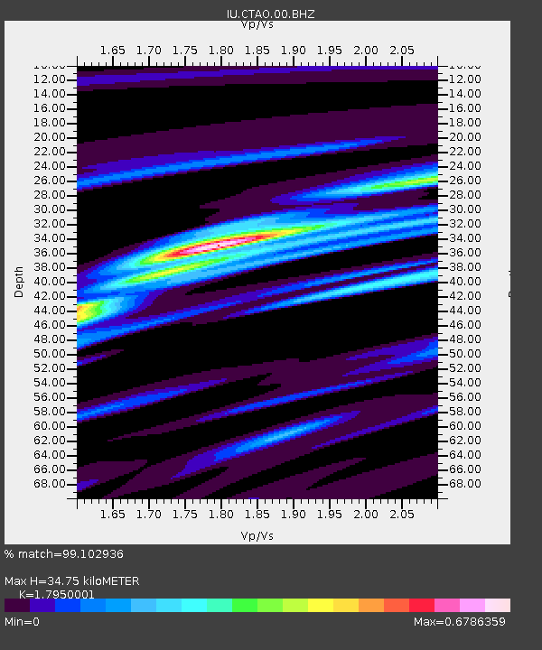
CTAO Charters Towers, Australia - Earthquake Result Viewer
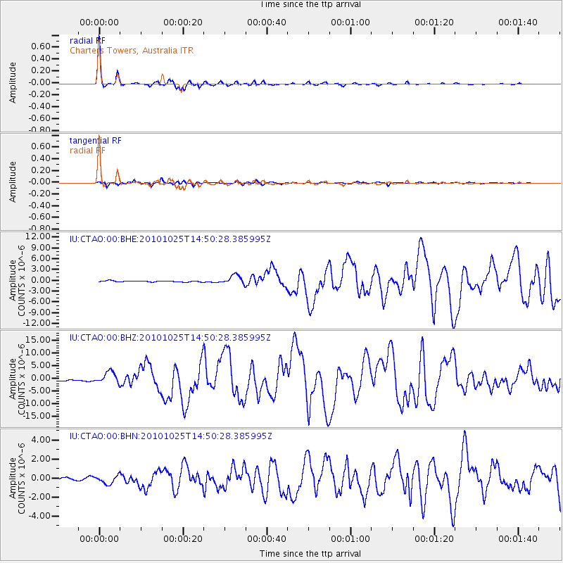
Earthquake location: Southern Sumatra, Indonesia
Earthquake latitude/longitude: -3.5/100.1
Earthquake time(UTC): 2010/10/25 (298) 14:42:22 GMT
Earthquake Depth: 20 km
Earthquake Magnitude: 6.5 MB, 7.3 MS, 7.8 MW, 7.7 MW
Earthquake Catalog/Contributor: WHDF/NEIC
Network: IU Global Seismograph Network (GSN - IRIS/USGS)
Station: CTAO Charters Towers, Australia
Lat/Lon: 20.09 S/146.25 E
Elevation: 357 m
Distance: 47.9 deg
Az: 113.971 deg
Baz: 283.976 deg
Ray Param: 0.06966778
Estimated Moho Depth: 34.75 km
Estimated Crust Vp/Vs: 1.80
Assumed Crust Vp: 6.522 km/s
Estimated Crust Vs: 3.633 km/s
Estimated Crust Poisson's Ratio: 0.27
Radial Match: 99.102936 %
Radial Bump: 245
Transverse Match: 95.20524 %
Transverse Bump: 400
SOD ConfigId: 339645
Insert Time: 2011-02-24 08:26:56.944 +0000
GWidth: 2.5
Max Bumps: 400
Tol: 0.001

Signal To Noise

ChannelStoNSTALTA
IU:CTAO:00:BHZ:20101025T14:50:28.385995Z11.0229452.4507922E-62.2233552E-7
IU:CTAO:00:BHN:20101025T14:50:28.385995Z4.26968054.3501512E-71.0188471E-7
IU:CTAO:00:BHE:20101025T14:50:28.385995Z8.6255171.2857223E-61.4906033E-7
Arrivals
Ps4.5 SECOND
PpPs14 SECOND
PsPs/PpSs19 SECOND