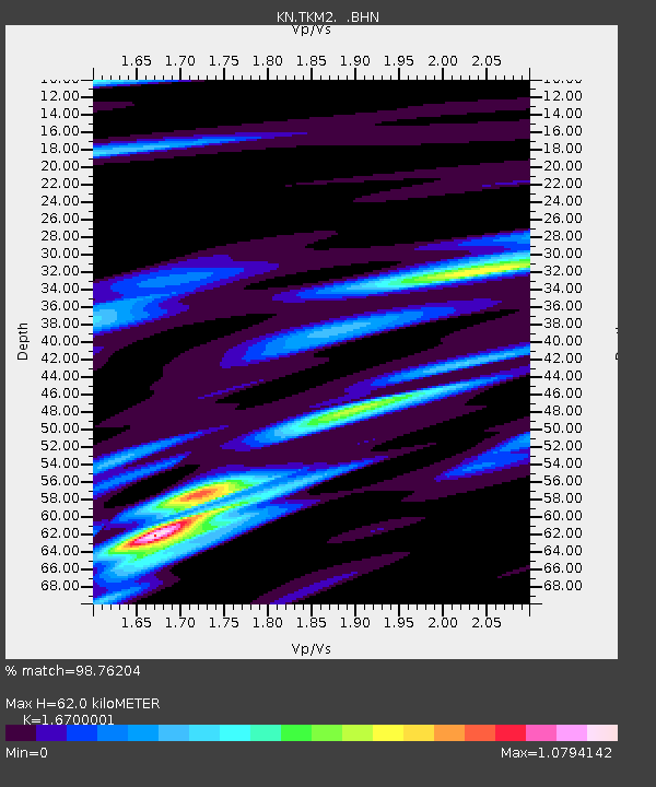
TKM2 KN.TKM2 - Earthquake Result Viewer
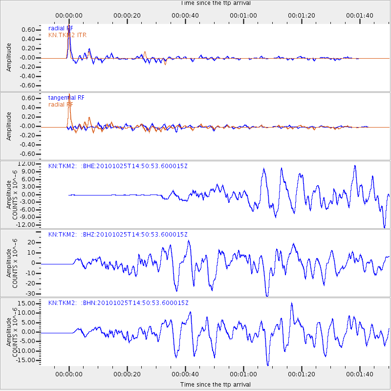
Earthquake location: Southern Sumatra, Indonesia
Earthquake latitude/longitude: -3.5/100.1
Earthquake time(UTC): 2010/10/25 (298) 14:42:22 GMT
Earthquake Depth: 20 km
Earthquake Magnitude: 6.5 MB, 7.3 MS, 7.8 MW, 7.7 MW
Earthquake Catalog/Contributor: WHDF/NEIC
Network: KN Kyrgyz Seismic Telemetry Network
Station: TKM2 KN.TKM2
Lat/Lon: 42.92 N/75.60 E
Elevation: 2020 m
Distance: 51.2 deg
Az: 337.013 deg
Baz: 147.949 deg
Ray Param: 0.067524604
Estimated Moho Depth: 62.0 km
Estimated Crust Vp/Vs: 1.67
Assumed Crust Vp: 6.306 km/s
Estimated Crust Vs: 3.776 km/s
Estimated Crust Poisson's Ratio: 0.22
Radial Match: 98.76204 %
Radial Bump: 321
Transverse Match: 91.994835 %
Transverse Bump: 400
SOD ConfigId: 339645
Insert Time: 2011-02-24 08:27:42.304 +0000
GWidth: 2.5
Max Bumps: 400
Tol: 0.001

Signal To Noise

ChannelStoNSTALTA
KN:TKM2: :BHZ:20101025T14:50:53.600015Z28.6118452.7199446E-69.5063584E-8
KN:TKM2: :BHN:20101025T14:50:53.600015Z14.7080231.0688806E-67.26733E-8
KN:TKM2: :BHE:20101025T14:50:53.600015Z17.1945698.539714E-74.9665186E-8
Arrivals
Ps7.0 SECOND
PpPs25 SECOND
PsPs/PpSs32 SECOND