You are here: Home > Network List > KZ - Kazakhstan Network Stations List
> Station ABKAR Akbulak array,AB31, Kazakhstan > Earthquake Result Viewer
ABKAR Akbulak array,AB31, Kazakhstan - Earthquake Result Viewer
| Earthquake location: |
Southern Sumatra, Indonesia |
| Earthquake latitude/longitude: |
-3.5/100.1 |
| Earthquake time(UTC): |
2010/10/25 (298) 14:42:22 GMT |
| Earthquake Depth: |
20 km |
| Earthquake Magnitude: |
6.5 MB, 7.3 MS, 7.8 MW, 7.7 MW |
| Earthquake Catalog/Contributor: |
WHDF/NEIC |
|
| Network: |
KZ Kazakhstan Network |
| Station: |
ABKAR Akbulak array,AB31, Kazakhstan |
| Lat/Lon: |
49.26 N/59.94 E |
| Elevation: |
362 m |
|
| Distance: |
63.0 deg |
| Az: |
331.697 deg |
| Baz: |
133.754 deg |
| Ray Param: |
0.05985287 |
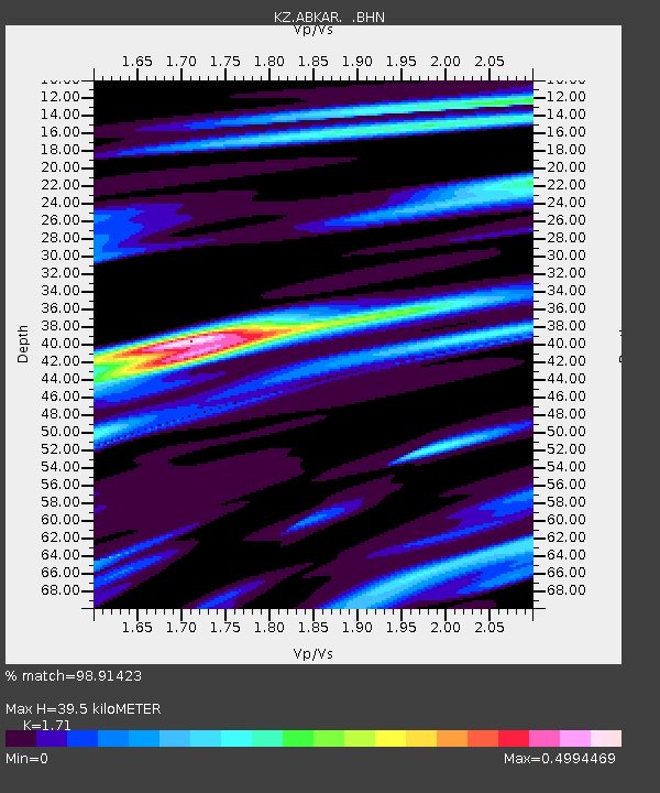
| Estimated Moho Depth: |
39.5 km |
| Estimated Crust Vp/Vs: |
1.71 |
| Assumed Crust Vp: |
6.35 km/s |
| Estimated Crust Vs: |
3.713 km/s |
| Estimated Crust Poisson's Ratio: |
0.24 |
|
| Radial Match: |
98.91423 % |
| Radial Bump: |
215 |
| Transverse Match: |
94.78393 % |
| Transverse Bump: |
390 |
| SOD ConfigId: |
339645 |
| Insert Time: |
2011-02-24 08:28:02.313 +0000 |
| GWidth: |
2.5 |
| Max Bumps: |
400 |
| Tol: |
0.001 |
|

Signal To Noise
| Channel | StoN | STA | LTA |
| KZ:ABKAR: :BHZ:20101025T14:52:16.600015Z | 35.193577 | 3.4473674E-6 | 9.795445E-8 |
| KZ:ABKAR: :BHN:20101025T14:52:16.600015Z | 8.556476 | 8.645007E-7 | 1.0103467E-7 |
| KZ:ABKAR: :BHE:20101025T14:52:16.600015Z | 17.112839 | 1.5570289E-6 | 9.098601E-8 |
| Arrivals |
| Ps | 4.6 SECOND |
| PpPs | 16 SECOND |
| PsPs/PpSs | 21 SECOND |


