You are here: Home > Network List > AK - Alaska Regional Network Stations List
> Station GRNC Granite Creek, AK, USA > Earthquake Result Viewer
GRNC Granite Creek, AK, USA - Earthquake Result Viewer
| Earthquake location: |
Eastern New Guinea Reg., P.N.G. |
| Earthquake latitude/longitude: |
-5.4/146.9 |
| Earthquake time(UTC): |
2023/03/14 (073) 00:49:08 GMT |
| Earthquake Depth: |
213 km |
| Earthquake Magnitude: |
6.3 mww |
| Earthquake Catalog/Contributor: |
NEIC PDE/us |
|
| Network: |
AK Alaska Regional Network |
| Station: |
GRNC Granite Creek, AK, USA |
| Lat/Lon: |
60.73 N/141.76 W |
| Elevation: |
2116 m |
|
| Distance: |
85.7 deg |
| Az: |
27.841 deg |
| Baz: |
251.119 deg |
| Ray Param: |
0.044062633 |
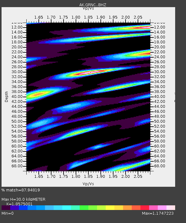
| Estimated Moho Depth: |
30.0 km |
| Estimated Crust Vp/Vs: |
1.86 |
| Assumed Crust Vp: |
6.566 km/s |
| Estimated Crust Vs: |
3.535 km/s |
| Estimated Crust Poisson's Ratio: |
0.30 |
|
| Radial Match: |
87.94819 % |
| Radial Bump: |
397 |
| Transverse Match: |
81.929306 % |
| Transverse Bump: |
383 |
| SOD ConfigId: |
34243671 |
| Insert Time: |
2024-05-03 08:04:07.020 +0000 |
| GWidth: |
2.5 |
| Max Bumps: |
400 |
| Tol: |
0.001 |
|

Signal To Noise
| Channel | StoN | STA | LTA |
| AK:GRNC: :BHZ:20230314T01:00:52.147973Z | 16.335987 | 3.1485279E-6 | 1.927357E-7 |
| AK:GRNC: :BHN:20230314T01:00:52.147973Z | 6.5877013 | 7.26951E-7 | 1.1034972E-7 |
| AK:GRNC: :BHE:20230314T01:00:52.147973Z | 10.530951 | 1.1636461E-6 | 1.1049772E-7 |
| Arrivals |
| Ps | 4.0 SECOND |
| PpPs | 13 SECOND |
| PsPs/PpSs | 17 SECOND |


