You are here: Home > Network List > AZ - ANZA Regional Network Stations List
> Station ELKS AZ.ELKS > Earthquake Result Viewer
ELKS AZ.ELKS - Earthquake Result Viewer
| Earthquake location: |
Near Coast Of Nicaragua |
| Earthquake latitude/longitude: |
11.1/-86.1 |
| Earthquake time(UTC): |
1996/11/17 (322) 19:17:41 GMT |
| Earthquake Depth: |
33 km |
| Earthquake Magnitude: |
5.5 MB, 5.6 MS, 5.9 UNKNOWN, 5.9 MW |
| Earthquake Catalog/Contributor: |
WHDF/NEIC |
|
| Network: |
AZ ANZA Regional Network |
| Station: |
ELKS AZ.ELKS |
| Lat/Lon: |
33.58 N/116.45 W |
| Elevation: |
1169 m |
|
| Distance: |
35.7 deg |
| Az: |
313.647 deg |
| Baz: |
121.696 deg |
| Ray Param: |
0.077012695 |
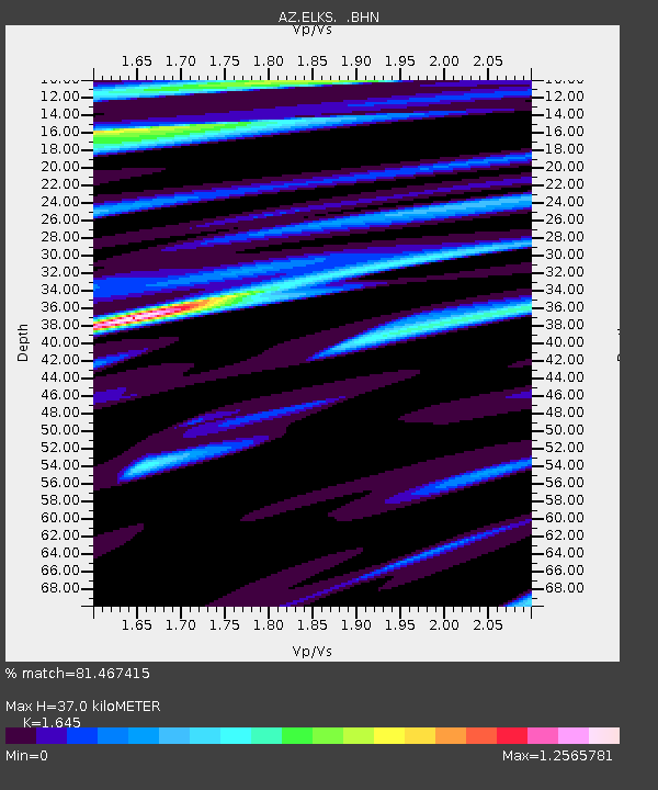
| Estimated Moho Depth: |
37.0 km |
| Estimated Crust Vp/Vs: |
1.64 |
| Assumed Crust Vp: |
6.264 km/s |
| Estimated Crust Vs: |
3.808 km/s |
| Estimated Crust Poisson's Ratio: |
0.21 |
|
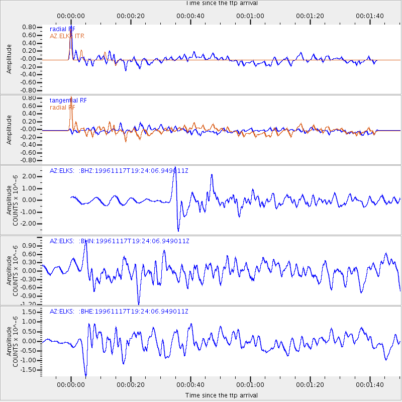
| Radial Match: |
81.467415 % |
| Radial Bump: |
400 |
| Transverse Match: |
56.622524 % |
| Transverse Bump: |
400 |
| SOD ConfigId: |
9875 |
| Insert Time: |
2010-02-26 19:08:25.350 +0000 |
| GWidth: |
2.5 |
| Max Bumps: |
400 |
| Tol: |
0.001 |
|
Signal To Noise
| Channel | StoN | STA | LTA |
| AZ:ELKS: :BHN:19961117T19:24:06.949011Z | 1.767117 | 3.802003E-7 | 2.1515287E-7 |
| AZ:ELKS: :BHE:19961117T19:24:06.949011Z | 3.1923053 | 5.3958354E-7 | 1.690263E-7 |
| AZ:ELKS: :BHZ:19961117T19:24:06.949011Z | 4.039883 | 9.4319665E-7 | 2.3347127E-7 |
| Arrivals |
| Ps | 4.1 SECOND |
| PpPs | 14 SECOND |
| PsPs/PpSs | 19 SECOND |


