You are here: Home > Network List > AZ - ANZA Regional Network Stations List
> Station ELKS AZ.ELKS > Earthquake Result Viewer
ELKS AZ.ELKS - Earthquake Result Viewer

| Earthquake location: |
Solomon Islands |
| Earthquake latitude/longitude: |
-7.3/155.8 |
| Earthquake time(UTC): |
1996/09/06 (250) 12:39:41 GMT |
| Earthquake Depth: |
33 km |
| Earthquake Magnitude: |
5.5 MB, 5.8 MS, 5.9 UNKNOWN, 5.9 MW |
| Earthquake Catalog/Contributor: |
WHDF/NEIC |
|
| Network: |
AZ ANZA Regional Network |
| Station: |
ELKS AZ.ELKS |
| Lat/Lon: |
33.58 N/116.45 W |
| Elevation: |
1169 m |
|
| Distance: |
92.1 deg |
| Az: |
56.585 deg |
| Baz: |
262.72 deg |
| Ray Param: |
0.04150343 |
| Estimated Moho Depth: |
10.0 km |
| Estimated Crust Vp/Vs: |
1.60 |
| Assumed Crust Vp: |
6.264 km/s |
| Estimated Crust Vs: |
3.915 km/s |
| Estimated Crust Poisson's Ratio: |
0.18 |
|
| Radial Match: |
100.0 % |
| Radial Bump: |
2 |
| Transverse Match: |
100.0 % |
| Transverse Bump: |
2 |
| SOD ConfigId: |
9875 |
| Insert Time: |
2010-02-26 19:08:26.282 +0000 |
| GWidth: |
2.5 |
| Max Bumps: |
400 |
| Tol: |
0.001 |
|
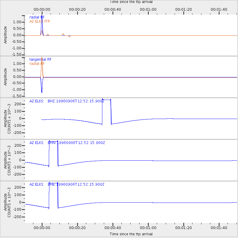
Signal To Noise
| Channel | StoN | STA | LTA |
| AZ:ELKS: :BHN:19960906T12:52:15.900Z | 13.545426 | 0.1174 | 0.008667132 |
| AZ:ELKS: :BHE:19960906T12:52:15.900Z | 13.54536 | 0.11740244 | 0.008667355 |
| AZ:ELKS: :BHZ:19960906T12:52:15.900Z | 13.545443 | 0.117402725 | 0.008667323 |
| Arrivals |
| Ps | 1.0 SECOND |
| PpPs | 4.1 SECOND |
| PsPs/PpSs | 5.0 SECOND |


