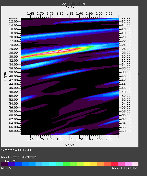
ELKS AZ.ELKS - Earthquake Result Viewer

Earthquake location: Bonin Islands, Japan Region
Earthquake latitude/longitude: 28.0/143.5
Earthquake time(UTC): 1996/11/06 (311) 20:00:58 GMT
Earthquake Depth: 9.0 km
Earthquake Magnitude: 6.4 MB, 6.5 MS, 6.6 UNKNOWN, 6.4 ME
Earthquake Catalog/Contributor: WHDF/NEIC
Network: AZ ANZA Regional Network
Station: ELKS AZ.ELKS
Lat/Lon: 33.58 N/116.45 W
Elevation: 1169 m
Distance: 82.6 deg
Az: 55.996 deg
Baz: 298.586 deg
Ray Param: 0.04677525
Estimated Moho Depth: 27.0 km
Estimated Crust Vp/Vs: 1.79
Assumed Crust Vp: 6.264 km/s
Estimated Crust Vs: 3.499 km/s
Estimated Crust Poisson's Ratio: 0.27
Radial Match: 90.055115 %
Radial Bump: 383
Transverse Match: 84.33714 %
Transverse Bump: 400
SOD ConfigId: 6273
Insert Time: 2010-02-26 19:08:30.698 +0000
GWidth: 2.5
Max Bumps: 400
Tol: 0.001

Signal To Noise

ChannelStoNSTALTA
AZ:ELKS: :BHN:19961106T20:12:50.750012Z1.80443982.2800035E-71.263552E-7
AZ:ELKS: :BHE:19961106T20:12:50.750012Z1.60168172.9892394E-71.8663131E-7
AZ:ELKS: :BHZ:19961106T20:12:50.750012Z2.793877.664968E-72.7434947E-7
Arrivals
Ps3.5 SECOND
PpPs12 SECOND
PsPs/PpSs15 SECOND