You are here: Home > Network List > AZ - ANZA Regional Network Stations List
> Station ELKS AZ.ELKS > Earthquake Result Viewer
ELKS AZ.ELKS - Earthquake Result Viewer
| Earthquake location: |
Tonga Islands |
| Earthquake latitude/longitude: |
-15.3/-173.1 |
| Earthquake time(UTC): |
1996/08/05 (218) 02:08:58 GMT |
| Earthquake Depth: |
41 km |
| Earthquake Magnitude: |
6.0 MB, 6.7 MS, 6.7 UNKNOWN, 6.2 ME |
| Earthquake Catalog/Contributor: |
WHDF/NEIC |
|
| Network: |
AZ ANZA Regional Network |
| Station: |
ELKS AZ.ELKS |
| Lat/Lon: |
33.58 N/116.45 W |
| Elevation: |
1169 m |
|
| Distance: |
72.6 deg |
| Az: |
46.961 deg |
| Baz: |
237.673 deg |
| Ray Param: |
0.053465944 |
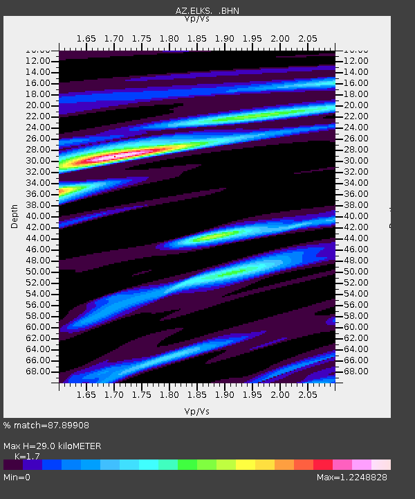
| Estimated Moho Depth: |
29.0 km |
| Estimated Crust Vp/Vs: |
1.70 |
| Assumed Crust Vp: |
6.264 km/s |
| Estimated Crust Vs: |
3.684 km/s |
| Estimated Crust Poisson's Ratio: |
0.24 |
|
| Radial Match: |
87.89908 % |
| Radial Bump: |
400 |
| Transverse Match: |
65.357376 % |
| Transverse Bump: |
400 |
| SOD ConfigId: |
6273 |
| Insert Time: |
2010-02-26 19:08:33.815 +0000 |
| GWidth: |
2.5 |
| Max Bumps: |
400 |
| Tol: |
0.001 |
|
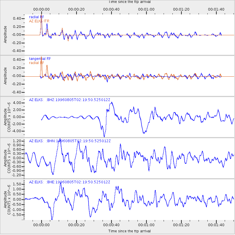
Signal To Noise
| Channel | StoN | STA | LTA |
| AZ:ELKS: :BHN:19960805T02:19:50.525012Z | 1.5528889 | 3.157766E-7 | 2.0334782E-7 |
| AZ:ELKS: :BHE:19960805T02:19:50.525012Z | 1.6785333 | 3.3362596E-7 | 1.987604E-7 |
| AZ:ELKS: :BHZ:19960805T02:19:50.525012Z | 5.297506 | 1.3406741E-6 | 2.5307648E-7 |
| Arrivals |
| Ps | 3.4 SECOND |
| PpPs | 12 SECOND |
| PsPs/PpSs | 15 SECOND |


