You are here: Home > Network List > AZ - ANZA Regional Network Stations List
> Station ELKS AZ.ELKS > Earthquake Result Viewer
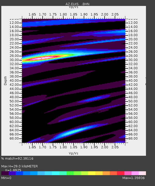
ELKS AZ.ELKS - Earthquake Result Viewer
| Earthquake location: |
South Of Fiji Islands |
| Earthquake latitude/longitude: |
-26.8/-177.2 |
| Earthquake time(UTC): |
1996/07/23 (205) 03:32:12 GMT |
| Earthquake Depth: |
33 km |
| Earthquake Magnitude: |
5.8 MB, 6.4 MS, 6.5 UNKNOWN, 6.5 MW |
| Earthquake Catalog/Contributor: |
WHDF/NEIC |
|
| Network: |
AZ ANZA Regional Network |
| Station: |
ELKS AZ.ELKS |
| Lat/Lon: |
33.58 N/116.45 W |
| Elevation: |
1169 m |
|
| Distance: |
83.2 deg |
| Az: |
47.181 deg |
| Baz: |
231.782 deg |
| Ray Param: |
0.04630693 |
| Estimated Moho Depth: |
29.0 km |
| Estimated Crust Vp/Vs: |
1.69 |
| Assumed Crust Vp: |
6.264 km/s |
| Estimated Crust Vs: |
3.701 km/s |
| Estimated Crust Poisson's Ratio: |
0.23 |
|
| Radial Match: |
92.39116 % |
| Radial Bump: |
400 |
| Transverse Match: |
77.141525 % |
| Transverse Bump: |
400 |
| SOD ConfigId: |
6273 |
| Insert Time: |
2010-02-26 19:08:35.639 +0000 |
| GWidth: |
2.5 |
| Max Bumps: |
400 |
| Tol: |
0.001 |
|

Signal To Noise
| Channel | StoN | STA | LTA |
| AZ:ELKS: :BHN:19960723T03:44:04.399011Z | 1.7279158 | 3.1737864E-7 | 1.8367714E-7 |
| AZ:ELKS: :BHE:19960723T03:44:04.399011Z | 0.8229956 | 1.05953376E-7 | 1.2874112E-7 |
| AZ:ELKS: :BHZ:19960723T03:44:04.399011Z | 3.472347 | 3.790478E-7 | 1.0916184E-7 |
| Arrivals |
| Ps | 3.3 SECOND |
| PpPs | 12 SECOND |
| PsPs/PpSs | 15 SECOND |


