You are here: Home > Network List > AZ - ANZA Regional Network Stations List
> Station ELKS AZ.ELKS > Earthquake Result Viewer
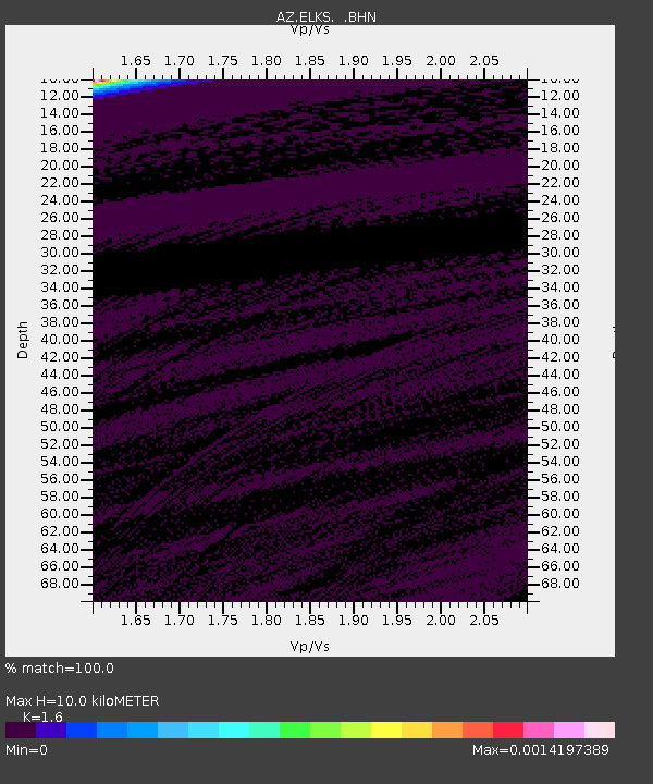
ELKS AZ.ELKS - Earthquake Result Viewer
| Earthquake location: |
Solomon Islands |
| Earthquake latitude/longitude: |
-10.8/161.4 |
| Earthquake time(UTC): |
1996/08/02 (215) 12:55:29 GMT |
| Earthquake Depth: |
33 km |
| Earthquake Magnitude: |
6.2 MB, 7.1 MS, 6.9 UNKNOWN, 6.9 MW |
| Earthquake Catalog/Contributor: |
WHDF/NEIC |
|
| Network: |
AZ ANZA Regional Network |
| Station: |
ELKS AZ.ELKS |
| Lat/Lon: |
33.58 N/116.45 W |
| Elevation: |
1169 m |
|
| Distance: |
89.4 deg |
| Az: |
55.786 deg |
| Baz: |
256.745 deg |
| Ray Param: |
0.041836724 |
| Estimated Moho Depth: |
10.0 km |
| Estimated Crust Vp/Vs: |
1.60 |
| Assumed Crust Vp: |
6.264 km/s |
| Estimated Crust Vs: |
3.915 km/s |
| Estimated Crust Poisson's Ratio: |
0.18 |
|
| Radial Match: |
100.0 % |
| Radial Bump: |
2 |
| Transverse Match: |
100.0 % |
| Transverse Bump: |
2 |
| SOD ConfigId: |
6273 |
| Insert Time: |
2010-02-26 19:08:37.156 +0000 |
| GWidth: |
2.5 |
| Max Bumps: |
400 |
| Tol: |
0.001 |
|

Signal To Noise
| Channel | StoN | STA | LTA |
| AZ:ELKS: :BHN:19960802T13:07:51.375012Z | 7.990911 | 0.044460967 | 0.0055639422 |
| AZ:ELKS: :BHE:19960802T13:07:51.375012Z | 7.9909387 | 0.04446181 | 0.0055640284 |
| AZ:ELKS: :BHZ:19960802T13:07:51.375012Z | 7.9908495 | 0.0444615 | 0.0055640517 |
| Arrivals |
| Ps | 1.0 SECOND |
| PpPs | 4.1 SECOND |
| PsPs/PpSs | 5.0 SECOND |


