You are here: Home > Network List > TA - USArray Transportable Network (new EarthScope stations) Stations List
> Station Y12C Blythe, CA, USA > Earthquake Result Viewer
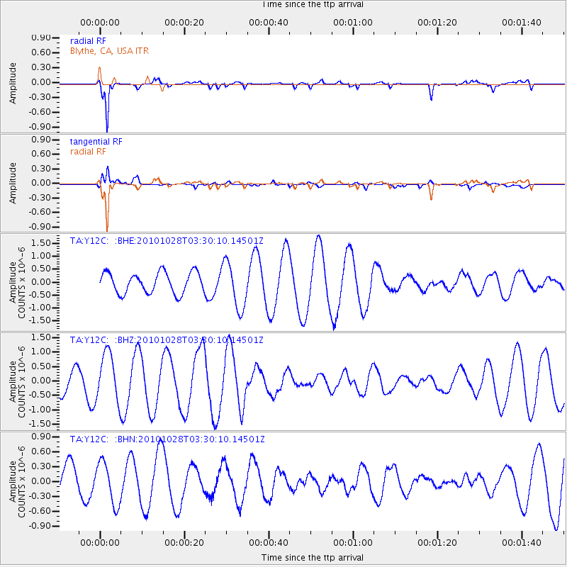
Y12C Blythe, CA, USA - Earthquake Result Viewer
*The percent match for this event was below the threshold and hence no stack was calculated.
| Earthquake location: |
New Ireland Region, P.N.G. |
| Earthquake latitude/longitude: |
-5.5/153.7 |
| Earthquake time(UTC): |
2010/10/28 (301) 03:17:24 GMT |
| Earthquake Depth: |
33 km |
| Earthquake Magnitude: |
5.7 MB, 5.7 MS, 5.8 MW, 5.6 MW |
| Earthquake Catalog/Contributor: |
WHDF/NEIC |
|
| Network: |
TA USArray Transportable Network (new EarthScope stations) |
| Station: |
Y12C Blythe, CA, USA |
| Lat/Lon: |
33.75 N/114.52 W |
| Elevation: |
196 m |
|
| Distance: |
94.5 deg |
| Az: |
56.651 deg |
| Baz: |
266.387 deg |
| Ray Param: |
$rayparam |
*The percent match for this event was below the threshold and hence was not used in the summary stack. |
|
| Radial Match: |
94.61397 % |
| Radial Bump: |
308 |
| Transverse Match: |
75.11157 % |
| Transverse Bump: |
400 |
| SOD ConfigId: |
339645 |
| Insert Time: |
2011-02-24 08:55:28.096 +0000 |
| GWidth: |
2.5 |
| Max Bumps: |
400 |
| Tol: |
0.001 |
|
Signal To Noise
| Channel | StoN | STA | LTA |
| TA:Y12C: :BHZ:20101028T03:30:10.14501Z | 1.398475 | 8.4215736E-7 | 6.021969E-7 |
| TA:Y12C: :BHN:20101028T03:30:10.14501Z | 1.3061161 | 4.37685E-7 | 3.351042E-7 |
| TA:Y12C: :BHE:20101028T03:30:10.14501Z | 2.2985704 | 9.174473E-7 | 3.9913826E-7 |
| Arrivals |
| Ps | |
| PpPs | |
| PsPs/PpSs | |


