You are here: Home > Network List > TA - USArray Transportable Network (new EarthScope stations) Stations List
> Station C06D Leavenworth, WQ, USA > Earthquake Result Viewer
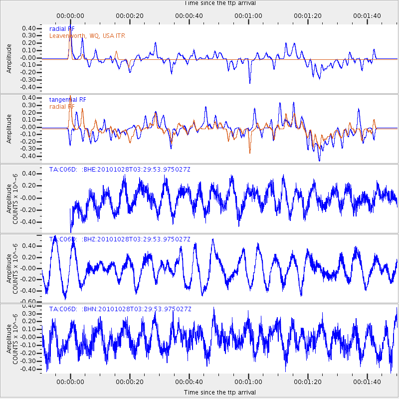
C06D Leavenworth, WQ, USA - Earthquake Result Viewer
*The percent match for this event was below the threshold and hence no stack was calculated.
| Earthquake location: |
New Ireland Region, P.N.G. |
| Earthquake latitude/longitude: |
-5.5/153.7 |
| Earthquake time(UTC): |
2010/10/28 (301) 03:17:24 GMT |
| Earthquake Depth: |
33 km |
| Earthquake Magnitude: |
5.7 MB, 5.7 MS, 5.8 MW, 5.6 MW |
| Earthquake Catalog/Contributor: |
WHDF/NEIC |
|
| Network: |
TA USArray Transportable Network (new EarthScope stations) |
| Station: |
C06D Leavenworth, WQ, USA |
| Lat/Lon: |
47.92 N/120.89 W |
| Elevation: |
544 m |
|
| Distance: |
90.9 deg |
| Az: |
42.105 deg |
| Baz: |
262.892 deg |
| Ray Param: |
$rayparam |
*The percent match for this event was below the threshold and hence was not used in the summary stack. |
|
| Radial Match: |
47.13267 % |
| Radial Bump: |
400 |
| Transverse Match: |
32.225693 % |
| Transverse Bump: |
400 |
| SOD ConfigId: |
339645 |
| Insert Time: |
2011-02-24 08:55:43.172 +0000 |
| GWidth: |
2.5 |
| Max Bumps: |
400 |
| Tol: |
0.001 |
|
Signal To Noise
| Channel | StoN | STA | LTA |
| TA:C06D: :BHZ:20101028T03:29:53.975027Z | 1.6833143 | 2.875944E-7 | 1.7085009E-7 |
| TA:C06D: :BHN:20101028T03:29:53.975027Z | 0.83035374 | 2.2812327E-7 | 2.7473024E-7 |
| TA:C06D: :BHE:20101028T03:29:53.975027Z | 1.150124 | 2.1432805E-7 | 1.8635212E-7 |
| Arrivals |
| Ps | |
| PpPs | |
| PsPs/PpSs | |


