You are here: Home > Network List > TX - Texas Seismological Network Stations List
> Station TREL Terrell > Earthquake Result Viewer
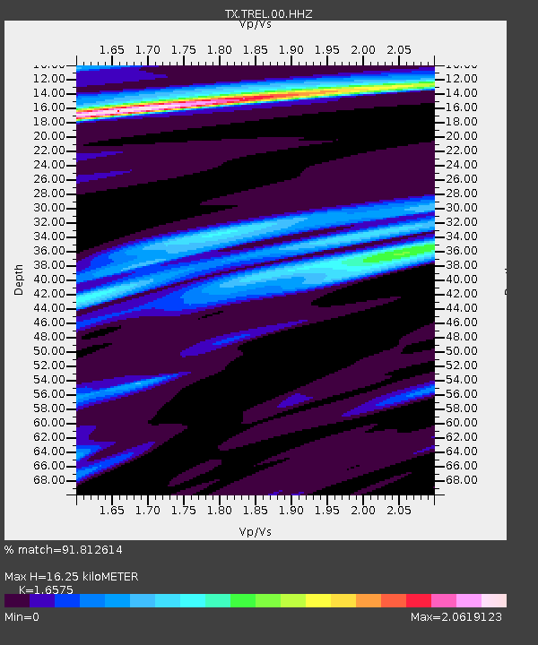
TREL Terrell - Earthquake Result Viewer
| Earthquake location: |
Near Coast Of Ecuador |
| Earthquake latitude/longitude: |
-2.9/-79.8 |
| Earthquake time(UTC): |
2023/03/18 (077) 17:12:53 GMT |
| Earthquake Depth: |
66 km |
| Earthquake Magnitude: |
6.7 Mww |
| Earthquake Catalog/Contributor: |
NEIC PDE/us |
|
| Network: |
TX Texas Seismological Network |
| Station: |
TREL Terrell |
| Lat/Lon: |
32.73 N/96.09 W |
| Elevation: |
174 m |
|
| Distance: |
38.6 deg |
| Az: |
337.735 deg |
| Baz: |
153.322 deg |
| Ray Param: |
0.07529797 |
| Estimated Moho Depth: |
16.25 km |
| Estimated Crust Vp/Vs: |
1.66 |
| Assumed Crust Vp: |
6.38 km/s |
| Estimated Crust Vs: |
3.849 km/s |
| Estimated Crust Poisson's Ratio: |
0.21 |
|
| Radial Match: |
91.812614 % |
| Radial Bump: |
332 |
| Transverse Match: |
71.90876 % |
| Transverse Bump: |
400 |
| SOD ConfigId: |
34243671 |
| Insert Time: |
2024-05-03 09:28:48.299 +0000 |
| GWidth: |
2.5 |
| Max Bumps: |
400 |
| Tol: |
0.001 |
|

Signal To Noise
| Channel | StoN | STA | LTA |
| TX:TREL:00:HHZ:20230318T17:19:38.275008Z | 14.08823 | 4.191437E-6 | 2.9751337E-7 |
| TX:TREL:00:HH1:20230318T17:19:38.275008Z | 1.8580575 | 7.2641836E-7 | 3.909558E-7 |
| TX:TREL:00:HH2:20230318T17:19:38.275008Z | 5.17528 | 1.3072341E-6 | 2.5259195E-7 |
| Arrivals |
| Ps | 1.8 SECOND |
| PpPs | 6.3 SECOND |
| PsPs/PpSs | 8.1 SECOND |


