You are here: Home > Network List > AZ - ANZA Regional Network Stations List
> Station ELKS AZ.ELKS > Earthquake Result Viewer
ELKS AZ.ELKS - Earthquake Result Viewer

| Earthquake location: |
Kermadec Islands Region |
| Earthquake latitude/longitude: |
-28.2/-178.4 |
| Earthquake time(UTC): |
1997/04/12 (102) 09:21:56 GMT |
| Earthquake Depth: |
184 km |
| Earthquake Magnitude: |
5.8 MB, 6.0 UNKNOWN, 6.0 MW |
| Earthquake Catalog/Contributor: |
WHDF/NEIC |
|
| Network: |
AZ ANZA Regional Network |
| Station: |
ELKS AZ.ELKS |
| Lat/Lon: |
33.58 N/116.45 W |
| Elevation: |
1169 m |
|
| Distance: |
84.9 deg |
| Az: |
47.683 deg |
| Baz: |
231.443 deg |
| Ray Param: |
0.04469452 |
| Estimated Moho Depth: |
27.5 km |
| Estimated Crust Vp/Vs: |
1.80 |
| Assumed Crust Vp: |
6.264 km/s |
| Estimated Crust Vs: |
3.48 km/s |
| Estimated Crust Poisson's Ratio: |
0.28 |
|
| Radial Match: |
85.33953 % |
| Radial Bump: |
400 |
| Transverse Match: |
57.941116 % |
| Transverse Bump: |
400 |
| SOD ConfigId: |
6273 |
| Insert Time: |
2010-02-26 19:08:40.818 +0000 |
| GWidth: |
2.5 |
| Max Bumps: |
400 |
| Tol: |
0.001 |
|
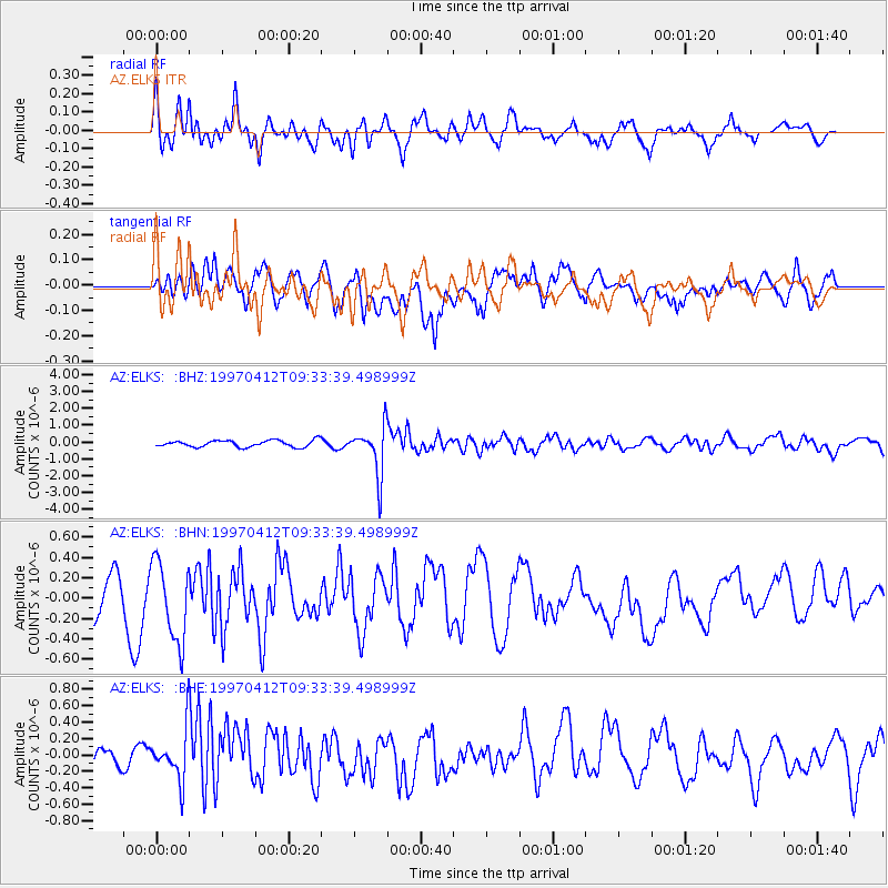
Signal To Noise
| Channel | StoN | STA | LTA |
| AZ:ELKS: :BHN:19970412T09:33:39.498999Z | 1.4500128 | 3.884328E-7 | 2.678823E-7 |
| AZ:ELKS: :BHE:19970412T09:33:39.498999Z | 2.5756898 | 3.019017E-7 | 1.17211975E-7 |
| AZ:ELKS: :BHZ:19970412T09:33:39.498999Z | 7.2419267 | 1.4273936E-6 | 1.9710137E-7 |
| Arrivals |
| Ps | 3.6 SECOND |
| PpPs | 12 SECOND |
| PsPs/PpSs | 16 SECOND |


