You are here: Home > Network List > CI - Caltech Regional Seismic Network Stations List
> Station RCT Rector, Visalia, CA, USA > Earthquake Result Viewer
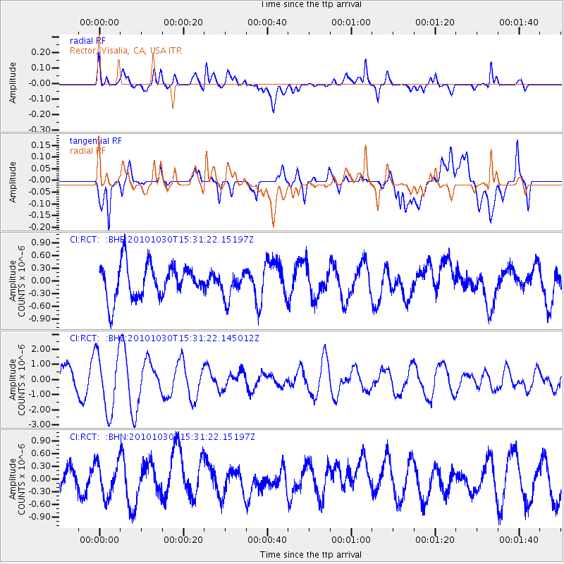
RCT Rector, Visalia, CA, USA - Earthquake Result Viewer
*The percent match for this event was below the threshold and hence no stack was calculated.
| Earthquake location: |
Pacific-Antarctic Ridge |
| Earthquake latitude/longitude: |
-56.6/-142.3 |
| Earthquake time(UTC): |
2010/10/30 (303) 15:18:33 GMT |
| Earthquake Depth: |
10 km |
| Earthquake Magnitude: |
5.5 MB, 6.1 MS, 6.4 MW, 6.3 MW |
| Earthquake Catalog/Contributor: |
WHDF/NEIC |
|
| Network: |
CI Caltech Regional Seismic Network |
| Station: |
RCT Rector, Visalia, CA, USA |
| Lat/Lon: |
36.31 N/119.24 W |
| Elevation: |
107 m |
|
| Distance: |
94.6 deg |
| Az: |
18.497 deg |
| Baz: |
192.55 deg |
| Ray Param: |
$rayparam |
*The percent match for this event was below the threshold and hence was not used in the summary stack. |
|
| Radial Match: |
74.71068 % |
| Radial Bump: |
400 |
| Transverse Match: |
61.07877 % |
| Transverse Bump: |
400 |
| SOD ConfigId: |
343573 |
| Insert Time: |
2011-03-03 07:36:38.147 +0000 |
| GWidth: |
2.5 |
| Max Bumps: |
400 |
| Tol: |
0.001 |
|
Signal To Noise
| Channel | StoN | STA | LTA |
| CI:RCT: :BHZ:20101030T15:31:22.145012Z | 2.2815804 | 1.9643446E-6 | 8.6095787E-7 |
| CI:RCT: :BHN:20101030T15:31:22.15197Z | 1.1382427 | 3.982845E-7 | 3.4991177E-7 |
| CI:RCT: :BHE:20101030T15:31:22.15197Z | 0.82973754 | 3.3118081E-7 | 3.9913922E-7 |
| Arrivals |
| Ps | |
| PpPs | |
| PsPs/PpSs | |


