You are here: Home > Network List > TA - USArray Transportable Network (new EarthScope stations) Stations List
> Station O03D Paynes Creek, CA, USA > Earthquake Result Viewer
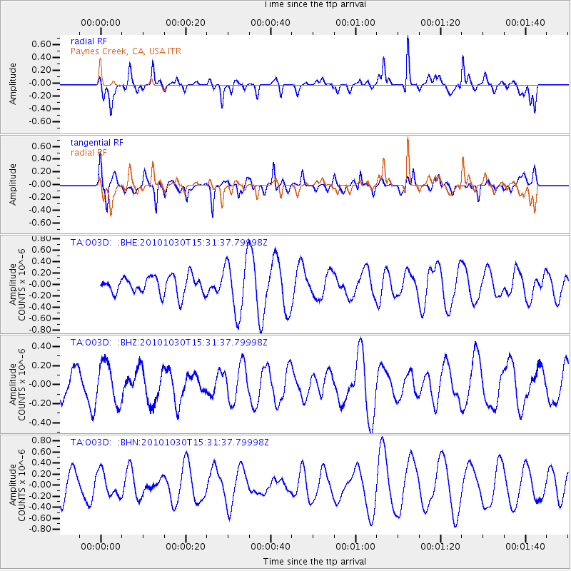
O03D Paynes Creek, CA, USA - Earthquake Result Viewer
*The percent match for this event was below the threshold and hence no stack was calculated.
| Earthquake location: |
Pacific-Antarctic Ridge |
| Earthquake latitude/longitude: |
-56.6/-142.3 |
| Earthquake time(UTC): |
2010/10/30 (303) 15:18:33 GMT |
| Earthquake Depth: |
10 km |
| Earthquake Magnitude: |
5.5 MB, 6.1 MS, 6.4 MW, 6.3 MW |
| Earthquake Catalog/Contributor: |
WHDF/NEIC |
|
| Network: |
TA USArray Transportable Network (new EarthScope stations) |
| Station: |
O03D Paynes Creek, CA, USA |
| Lat/Lon: |
40.29 N/121.80 W |
| Elevation: |
968 m |
|
| Distance: |
98.1 deg |
| Az: |
15.689 deg |
| Baz: |
191.28 deg |
| Ray Param: |
$rayparam |
*The percent match for this event was below the threshold and hence was not used in the summary stack. |
|
| Radial Match: |
69.85815 % |
| Radial Bump: |
369 |
| Transverse Match: |
61.403114 % |
| Transverse Bump: |
400 |
| SOD ConfigId: |
343573 |
| Insert Time: |
2011-03-03 07:38:57.445 +0000 |
| GWidth: |
2.5 |
| Max Bumps: |
400 |
| Tol: |
0.001 |
|
Signal To Noise
| Channel | StoN | STA | LTA |
| TA:O03D: :BHZ:20101030T15:31:37.79998Z | 1.0269923 | 2.0917508E-7 | 2.0367736E-7 |
| TA:O03D: :BHN:20101030T15:31:37.79998Z | 0.62899286 | 2.1894225E-7 | 3.4808386E-7 |
| TA:O03D: :BHE:20101030T15:31:37.79998Z | 3.1088433 | 4.8647786E-7 | 1.5648196E-7 |
| Arrivals |
| Ps | |
| PpPs | |
| PsPs/PpSs | |


