You are here: Home > Network List > BK - Berkeley Digital Seismograph Network Stations List
> Station HUMO Hull Mountain, OR > Earthquake Result Viewer
HUMO Hull Mountain, OR - Earthquake Result Viewer
*The percent match for this event was below the threshold and hence no stack was calculated.
| Earthquake location: |
New Britain Region, P.N.G. |
| Earthquake latitude/longitude: |
-6.4/150.2 |
| Earthquake time(UTC): |
2010/10/31 (304) 16:38:49 GMT |
| Earthquake Depth: |
10 km |
| Earthquake Magnitude: |
5.5 MB, 5.5 MS, 5.8 MW, 5.7 MW |
| Earthquake Catalog/Contributor: |
WHDF/NEIC |
|
| Network: |
BK Berkeley Digital Seismograph Network |
| Station: |
HUMO Hull Mountain, OR |
| Lat/Lon: |
42.61 N/122.96 W |
| Elevation: |
555 m |
|
| Distance: |
92.0 deg |
| Az: |
47.529 deg |
| Baz: |
263.218 deg |
| Ray Param: |
$rayparam |
*The percent match for this event was below the threshold and hence was not used in the summary stack. |
|
| Radial Match: |
72.284424 % |
| Radial Bump: |
400 |
| Transverse Match: |
58.620827 % |
| Transverse Bump: |
400 |
| SOD ConfigId: |
343573 |
| Insert Time: |
2011-03-03 07:40:23.133 +0000 |
| GWidth: |
2.5 |
| Max Bumps: |
400 |
| Tol: |
0.001 |
|
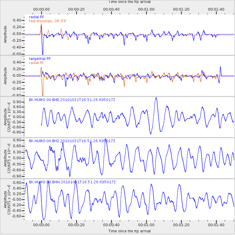
Signal To Noise
| Channel | StoN | STA | LTA |
| BK:HUMO:00:BHZ:20101031T16:51:26.695017Z | 0.81662565 | 3.3768603E-7 | 4.1351385E-7 |
| BK:HUMO:00:BHN:20101031T16:51:26.695017Z | 2.0824502 | 5.180042E-7 | 2.4874745E-7 |
| BK:HUMO:00:BHE:20101031T16:51:26.695017Z | 0.7824236 | 2.316102E-7 | 2.9601637E-7 |
| Arrivals |
| Ps | |
| PpPs | |
| PsPs/PpSs | |


