You are here: Home > Network List > KR - Kyrgyz Digital Network Stations List
> Station TRKS Terek-Say, Kyrgyzstan > Earthquake Result Viewer
TRKS Terek-Say, Kyrgyzstan - Earthquake Result Viewer
| Earthquake location: |
Solomon Islands |
| Earthquake latitude/longitude: |
-8.2/158.9 |
| Earthquake time(UTC): |
2023/03/27 (086) 22:19:15 GMT |
| Earthquake Depth: |
86 km |
| Earthquake Magnitude: |
6.1 mww |
| Earthquake Catalog/Contributor: |
NEIC PDE/us |
|
| Network: |
KR Kyrgyz Digital Network |
| Station: |
TRKS Terek-Say, Kyrgyzstan |
| Lat/Lon: |
41.46 N/71.17 E |
| Elevation: |
1518 m |
|
| Distance: |
93.7 deg |
| Az: |
311.186 deg |
| Baz: |
97.614 deg |
| Ray Param: |
0.041164044 |
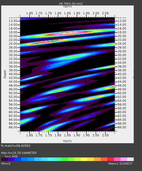
| Estimated Moho Depth: |
18.25 km |
| Estimated Crust Vp/Vs: |
1.85 |
| Assumed Crust Vp: |
6.236 km/s |
| Estimated Crust Vs: |
3.38 km/s |
| Estimated Crust Poisson's Ratio: |
0.29 |
|
| Radial Match: |
86.60592 % |
| Radial Bump: |
400 |
| Transverse Match: |
69.249016 % |
| Transverse Bump: |
400 |
| SOD ConfigId: |
34243671 |
| Insert Time: |
2024-05-03 13:18:18.207 +0000 |
| GWidth: |
2.5 |
| Max Bumps: |
400 |
| Tol: |
0.001 |
|

Signal To Noise
| Channel | StoN | STA | LTA |
| KR:TRKS:00:HHZ:20230327T22:31:51.570009Z | 8.9189415 | 6.929855E-7 | 7.769818E-8 |
| KR:TRKS:00:HHN:20230327T22:31:51.570009Z | 1.8657783 | 5.91395E-8 | 3.169696E-8 |
| KR:TRKS:00:HHE:20230327T22:31:51.570009Z | 12.740782 | 3.1694404E-7 | 2.4876341E-8 |
| Arrivals |
| Ps | 2.5 SECOND |
| PpPs | 8.2 SECOND |
| PsPs/PpSs | 11 SECOND |


