You are here: Home > Network List > TA - USArray Transportable Network (new EarthScope stations) Stations List
> Station I03D Drain, OR, USA > Earthquake Result Viewer
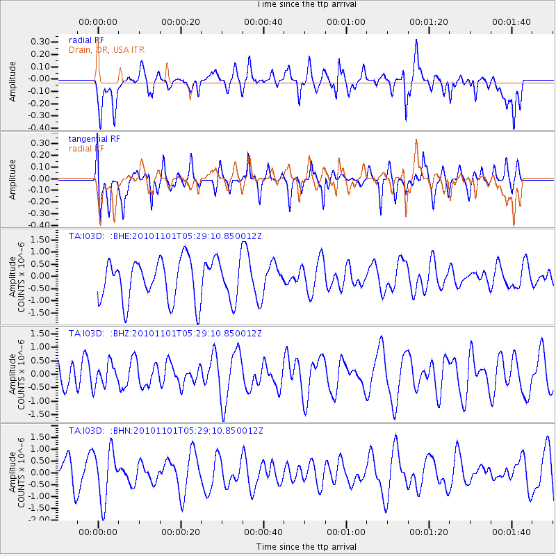
I03D Drain, OR, USA - Earthquake Result Viewer
*The percent match for this event was below the threshold and hence no stack was calculated.
| Earthquake location: |
New Britain Region, P.N.G. |
| Earthquake latitude/longitude: |
-6.4/150.2 |
| Earthquake time(UTC): |
2010/11/01 (305) 05:16:34 GMT |
| Earthquake Depth: |
8.7 km |
| Earthquake Magnitude: |
5.5 MB, 5.1 MS, 5.5 MW, 5.5 MW |
| Earthquake Catalog/Contributor: |
WHDF/NEIC |
|
| Network: |
TA USArray Transportable Network (new EarthScope stations) |
| Station: |
I03D Drain, OR, USA |
| Lat/Lon: |
43.70 N/123.35 W |
| Elevation: |
140 m |
|
| Distance: |
91.8 deg |
| Az: |
46.407 deg |
| Baz: |
262.958 deg |
| Ray Param: |
$rayparam |
*The percent match for this event was below the threshold and hence was not used in the summary stack. |
|
| Radial Match: |
44.817863 % |
| Radial Bump: |
400 |
| Transverse Match: |
53.877327 % |
| Transverse Bump: |
400 |
| SOD ConfigId: |
343573 |
| Insert Time: |
2011-03-03 07:47:04.432 +0000 |
| GWidth: |
2.5 |
| Max Bumps: |
400 |
| Tol: |
0.001 |
|
Signal To Noise
| Channel | StoN | STA | LTA |
| TA:I03D: :BHZ:20101101T05:29:10.850012Z | 1.0177937 | 3.950396E-7 | 3.8813332E-7 |
| TA:I03D: :BHN:20101101T05:29:10.850012Z | 1.5941119 | 1.0866676E-6 | 6.8167583E-7 |
| TA:I03D: :BHE:20101101T05:29:10.850012Z | 0.9734247 | 8.318676E-7 | 8.5457833E-7 |
| Arrivals |
| Ps | |
| PpPs | |
| PsPs/PpSs | |


