You are here: Home > Network List > YT07 - POLENET Stations List
> Station WHIT WHIT > Earthquake Result Viewer
WHIT WHIT - Earthquake Result Viewer
| Earthquake location: |
New Guinea, Papua New Guinea |
| Earthquake latitude/longitude: |
-4.3/143.2 |
| Earthquake time(UTC): |
2023/04/02 (092) 18:04:12 GMT |
| Earthquake Depth: |
74 km |
| Earthquake Magnitude: |
7.3 Mi |
| Earthquake Catalog/Contributor: |
NEIC PDE/pt |
|
| Network: |
YT POLENET |
| Station: |
WHIT WHIT |
| Lat/Lon: |
82.68 S/104.39 W |
| Elevation: |
2343 m |
|
| Distance: |
88.5 deg |
| Az: |
173.191 deg |
| Baz: |
247.24 deg |
| Ray Param: |
0.04238215 |
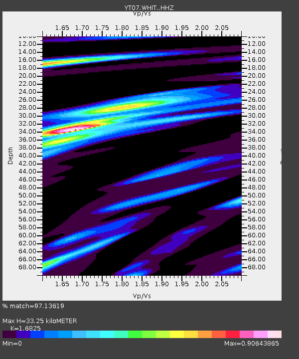
| Estimated Moho Depth: |
33.25 km |
| Estimated Crust Vp/Vs: |
1.68 |
| Assumed Crust Vp: |
6.356 km/s |
| Estimated Crust Vs: |
3.778 km/s |
| Estimated Crust Poisson's Ratio: |
0.23 |
|
| Radial Match: |
97.13619 % |
| Radial Bump: |
327 |
| Transverse Match: |
90.5843 % |
| Transverse Bump: |
400 |
| SOD ConfigId: |
34243671 |
| Insert Time: |
2024-05-03 14:22:27.101 +0000 |
| GWidth: |
2.5 |
| Max Bumps: |
400 |
| Tol: |
0.001 |
|

Signal To Noise
| Channel | StoN | STA | LTA |
| YT:WHIT: :HHZ:20230402T18:16:25.088989Z | 8.994109 | 1.1656427E-6 | 1.2960069E-7 |
| YT:WHIT: :HHN:20230402T18:16:25.088989Z | 2.8765984 | 3.515805E-7 | 1.2222092E-7 |
| YT:WHIT: :HHE:20230402T18:16:25.088989Z | 3.614083 | 4.4574725E-7 | 1.2333619E-7 |
| Arrivals |
| Ps | 3.7 SECOND |
| PpPs | 14 SECOND |
| PsPs/PpSs | 17 SECOND |


