You are here: Home > Network List > TA - USArray Transportable Network (new EarthScope stations) Stations List
> Station S28A Manter, KS, USA > Earthquake Result Viewer
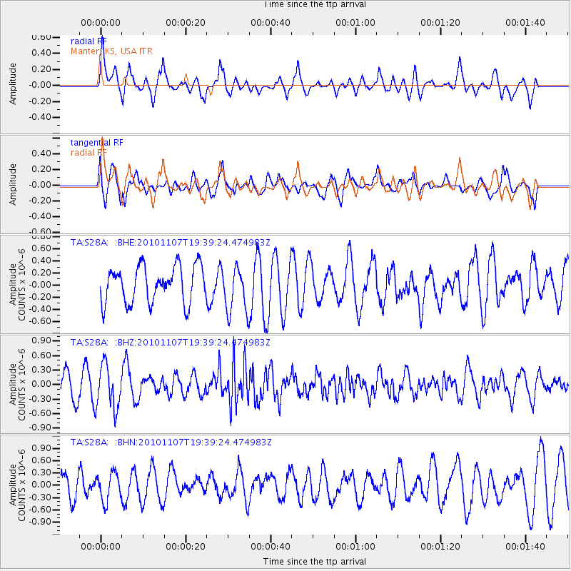
S28A Manter, KS, USA - Earthquake Result Viewer
*The percent match for this event was below the threshold and hence no stack was calculated.
| Earthquake location: |
Volcano Islands, Japan Region |
| Earthquake latitude/longitude: |
24.4/141.6 |
| Earthquake time(UTC): |
2010/11/07 (311) 19:26:49 GMT |
| Earthquake Depth: |
113 km |
| Earthquake Magnitude: |
5.7 MB, 5.6 MW, 5.6 MW |
| Earthquake Catalog/Contributor: |
WHDF/NEIC |
|
| Network: |
TA USArray Transportable Network (new EarthScope stations) |
| Station: |
S28A Manter, KS, USA |
| Lat/Lon: |
37.59 N/101.90 W |
| Elevation: |
1064 m |
|
| Distance: |
94.2 deg |
| Az: |
45.461 deg |
| Baz: |
305.097 deg |
| Ray Param: |
$rayparam |
*The percent match for this event was below the threshold and hence was not used in the summary stack. |
|
| Radial Match: |
56.93146 % |
| Radial Bump: |
400 |
| Transverse Match: |
56.92655 % |
| Transverse Bump: |
400 |
| SOD ConfigId: |
343573 |
| Insert Time: |
2011-03-05 07:43:25.532 +0000 |
| GWidth: |
2.5 |
| Max Bumps: |
400 |
| Tol: |
0.001 |
|
Signal To Noise
| Channel | StoN | STA | LTA |
| TA:S28A: :BHZ:20101107T19:39:24.474983Z | 1.6004852 | 4.3947688E-7 | 2.7458978E-7 |
| TA:S28A: :BHN:20101107T19:39:24.474983Z | 0.8542669 | 3.4974627E-7 | 4.0941103E-7 |
| TA:S28A: :BHE:20101107T19:39:24.474983Z | 1.2955067 | 3.8943324E-7 | 3.0060303E-7 |
| Arrivals |
| Ps | |
| PpPs | |
| PsPs/PpSs | |


