You are here: Home > Network List > TA - USArray Transportable Network (new EarthScope stations) Stations List
> Station G33A Ortonville, MN, USA > Earthquake Result Viewer
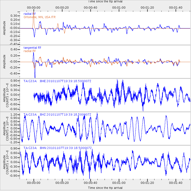
G33A Ortonville, MN, USA - Earthquake Result Viewer
*The percent match for this event was below the threshold and hence no stack was calculated.
| Earthquake location: |
Volcano Islands, Japan Region |
| Earthquake latitude/longitude: |
24.4/141.6 |
| Earthquake time(UTC): |
2010/11/07 (311) 19:26:49 GMT |
| Earthquake Depth: |
113 km |
| Earthquake Magnitude: |
5.7 MB, 5.6 MW, 5.6 MW |
| Earthquake Catalog/Contributor: |
WHDF/NEIC |
|
| Network: |
TA USArray Transportable Network (new EarthScope stations) |
| Station: |
G33A Ortonville, MN, USA |
| Lat/Lon: |
45.19 N/96.44 W |
| Elevation: |
338 m |
|
| Distance: |
92.9 deg |
| Az: |
36.912 deg |
| Baz: |
309.238 deg |
| Ray Param: |
$rayparam |
*The percent match for this event was below the threshold and hence was not used in the summary stack. |
|
| Radial Match: |
36.343918 % |
| Radial Bump: |
400 |
| Transverse Match: |
73.29673 % |
| Transverse Bump: |
400 |
| SOD ConfigId: |
343573 |
| Insert Time: |
2011-03-05 07:44:52.008 +0000 |
| GWidth: |
2.5 |
| Max Bumps: |
400 |
| Tol: |
0.001 |
|
Signal To Noise
| Channel | StoN | STA | LTA |
| TA:G33A: :BHZ:20101107T19:39:18.500007Z | 1.5968161 | 6.5788174E-7 | 4.1199596E-7 |
| TA:G33A: :BHN:20101107T19:39:18.500007Z | 0.9693427 | 3.0874187E-7 | 3.185064E-7 |
| TA:G33A: :BHE:20101107T19:39:18.500007Z | 1.5866694 | 4.0389705E-7 | 2.5455654E-7 |
| Arrivals |
| Ps | |
| PpPs | |
| PsPs/PpSs | |


