You are here: Home > Network List > KR - Kyrgyz Digital Network Stations List
> Station TRKS Terek-Say, Kyrgyzstan > Earthquake Result Viewer
TRKS Terek-Say, Kyrgyzstan - Earthquake Result Viewer
| Earthquake location: |
Philippine Islands Region |
| Earthquake latitude/longitude: |
13.8/125.5 |
| Earthquake time(UTC): |
2023/04/04 (094) 12:54:32 GMT |
| Earthquake Depth: |
15 km |
| Earthquake Magnitude: |
6.2 mww |
| Earthquake Catalog/Contributor: |
NEIC PDE/us |
|
| Network: |
KR Kyrgyz Digital Network |
| Station: |
TRKS Terek-Say, Kyrgyzstan |
| Lat/Lon: |
41.46 N/71.17 E |
| Elevation: |
1518 m |
|
| Distance: |
54.5 deg |
| Az: |
311.345 deg |
| Baz: |
103.928 deg |
| Ray Param: |
0.06543334 |
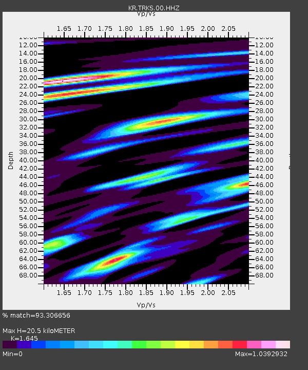
| Estimated Moho Depth: |
20.5 km |
| Estimated Crust Vp/Vs: |
1.64 |
| Assumed Crust Vp: |
6.236 km/s |
| Estimated Crust Vs: |
3.791 km/s |
| Estimated Crust Poisson's Ratio: |
0.21 |
|
| Radial Match: |
93.306656 % |
| Radial Bump: |
400 |
| Transverse Match: |
77.33605 % |
| Transverse Bump: |
400 |
| SOD ConfigId: |
34243671 |
| Insert Time: |
2024-05-03 15:26:40.674 +0000 |
| GWidth: |
2.5 |
| Max Bumps: |
400 |
| Tol: |
0.001 |
|

Signal To Noise
| Channel | StoN | STA | LTA |
| KR:TRKS:00:HHZ:20230404T13:03:28.090Z | 3.7645288 | 2.3662382E-7 | 6.285616E-8 |
| KR:TRKS:00:HHN:20230404T13:03:28.090Z | 1.0243549 | 5.7444957E-8 | 5.6079156E-8 |
| KR:TRKS:00:HHE:20230404T13:03:28.090Z | 3.309587 | 1.1187353E-7 | 3.3802866E-8 |
| Arrivals |
| Ps | 2.2 SECOND |
| PpPs | 8.2 SECOND |
| PsPs/PpSs | 10 SECOND |


