You are here: Home > Network List > AU - Australian Seismological Centre Stations List
> Station TOO Toolangi, Victoria > Earthquake Result Viewer
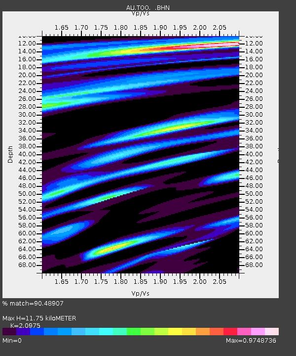
TOO Toolangi, Victoria - Earthquake Result Viewer
| Earthquake location: |
Southeast Indian Ridge |
| Earthquake latitude/longitude: |
-45.5/96.4 |
| Earthquake time(UTC): |
2010/11/10 (314) 04:05:24 GMT |
| Earthquake Depth: |
10 km |
| Earthquake Magnitude: |
6.0 MB, 6.5 MS, 6.5 MW, 6.4 MW |
| Earthquake Catalog/Contributor: |
WHDF/NEIC |
|
| Network: |
AU Australian Seismological Centre |
| Station: |
TOO Toolangi, Victoria |
| Lat/Lon: |
37.57 S/145.49 E |
| Elevation: |
604 m |
|
| Distance: |
37.1 deg |
| Az: |
95.485 deg |
| Baz: |
241.841 deg |
| Ray Param: |
0.07631607 |
| Estimated Moho Depth: |
11.75 km |
| Estimated Crust Vp/Vs: |
2.10 |
| Assumed Crust Vp: |
6.577 km/s |
| Estimated Crust Vs: |
3.136 km/s |
| Estimated Crust Poisson's Ratio: |
0.35 |
|
| Radial Match: |
90.48907 % |
| Radial Bump: |
292 |
| Transverse Match: |
67.618546 % |
| Transverse Bump: |
400 |
| SOD ConfigId: |
343573 |
| Insert Time: |
2011-03-05 07:49:54.134 +0000 |
| GWidth: |
2.5 |
| Max Bumps: |
400 |
| Tol: |
0.001 |
|

Signal To Noise
| Channel | StoN | STA | LTA |
| AU:TOO: :BHZ:20101110T04:12:04.094998Z | 5.415375 | 2.0979821E-6 | 3.8741214E-7 |
| AU:TOO: :BHN:20101110T04:12:04.094998Z | 2.1351647 | 5.939933E-7 | 2.7819553E-7 |
| AU:TOO: :BHE:20101110T04:12:04.094998Z | 2.8153403 | 8.821764E-7 | 3.1334628E-7 |
| Arrivals |
| Ps | 2.1 SECOND |
| PpPs | 5.2 SECOND |
| PsPs/PpSs | 7.3 SECOND |


