You are here: Home > Network List > G - GEOSCOPE Stations List
> Station FOMA Nahampoana reservation, Fort Dauphin, Madagascar > Earthquake Result Viewer
FOMA Nahampoana reservation, Fort Dauphin, Madagascar - Earthquake Result Viewer
| Earthquake location: |
Southeast Indian Ridge |
| Earthquake latitude/longitude: |
-45.5/96.4 |
| Earthquake time(UTC): |
2010/11/10 (314) 04:05:24 GMT |
| Earthquake Depth: |
10 km |
| Earthquake Magnitude: |
6.0 MB, 6.5 MS, 6.5 MW, 6.4 MW |
| Earthquake Catalog/Contributor: |
WHDF/NEIC |
|
| Network: |
G GEOSCOPE |
| Station: |
FOMA Nahampoana reservation, Fort Dauphin, Madagascar |
| Lat/Lon: |
24.98 S/46.98 E |
| Elevation: |
26 m |
|
| Distance: |
44.5 deg |
| Az: |
280.196 deg |
| Baz: |
130.255 deg |
| Ray Param: |
0.07190815 |
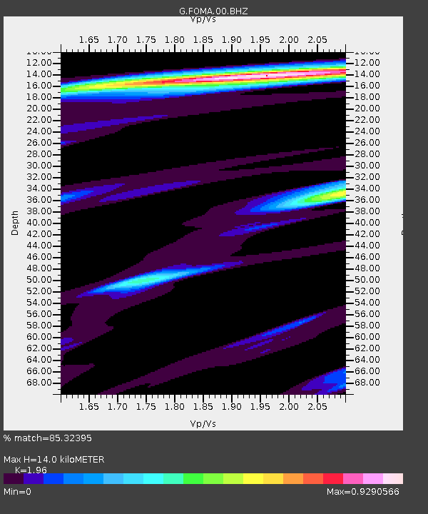
| Estimated Moho Depth: |
14.0 km |
| Estimated Crust Vp/Vs: |
1.96 |
| Assumed Crust Vp: |
6.183 km/s |
| Estimated Crust Vs: |
3.154 km/s |
| Estimated Crust Poisson's Ratio: |
0.32 |
|
| Radial Match: |
85.32395 % |
| Radial Bump: |
393 |
| Transverse Match: |
68.76083 % |
| Transverse Bump: |
400 |
| SOD ConfigId: |
343573 |
| Insert Time: |
2011-03-05 07:51:12.985 +0000 |
| GWidth: |
2.5 |
| Max Bumps: |
400 |
| Tol: |
0.001 |
|
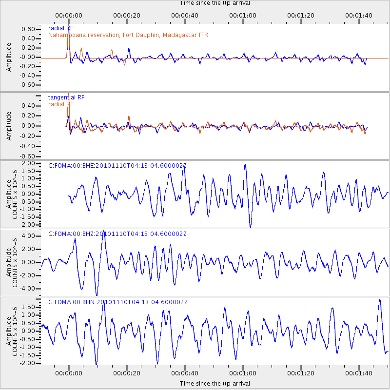
Signal To Noise
| Channel | StoN | STA | LTA |
| G:FOMA:00:BHZ:20101110T04:13:04.600002Z | 4.7811055 | 2.3645543E-6 | 4.9456224E-7 |
| G:FOMA:00:BHN:20101110T04:13:04.600002Z | 2.9521458 | 9.453323E-7 | 3.202187E-7 |
| G:FOMA:00:BHE:20101110T04:13:04.600002Z | 2.0181987 | 9.422914E-7 | 4.6689726E-7 |
| Arrivals |
| Ps | 2.3 SECOND |
| PpPs | 6.4 SECOND |
| PsPs/PpSs | 8.6 SECOND |


