You are here: Home > Network List > YT07 - POLENET Stations List
> Station UNGL UNGL > Earthquake Result Viewer
UNGL UNGL - Earthquake Result Viewer
| Earthquake location: |
Java, Indonesia |
| Earthquake latitude/longitude: |
-6.0/112.0 |
| Earthquake time(UTC): |
2023/04/14 (104) 09:55:45 GMT |
| Earthquake Depth: |
594 km |
| Earthquake Magnitude: |
7.0 mww |
| Earthquake Catalog/Contributor: |
NEIC PDE/us |
|
| Network: |
YT POLENET |
| Station: |
UNGL UNGL |
| Lat/Lon: |
79.77 S/82.52 W |
| Elevation: |
745 m |
|
| Distance: |
94.0 deg |
| Az: |
177.42 deg |
| Baz: |
194.512 deg |
| Ray Param: |
0.040581252 |
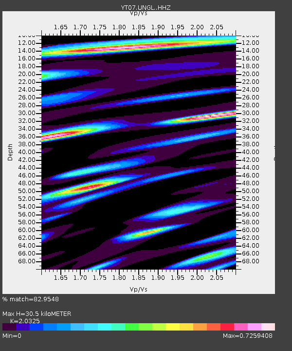
| Estimated Moho Depth: |
30.5 km |
| Estimated Crust Vp/Vs: |
2.03 |
| Assumed Crust Vp: |
6.182 km/s |
| Estimated Crust Vs: |
3.041 km/s |
| Estimated Crust Poisson's Ratio: |
0.34 |
|
| Radial Match: |
82.9548 % |
| Radial Bump: |
400 |
| Transverse Match: |
68.965546 % |
| Transverse Bump: |
400 |
| SOD ConfigId: |
34243671 |
| Insert Time: |
2024-05-03 18:01:31.601 +0000 |
| GWidth: |
2.5 |
| Max Bumps: |
400 |
| Tol: |
0.001 |
|

Signal To Noise
| Channel | StoN | STA | LTA |
| YT:UNGL: :HHZ:20230414T10:07:29.189011Z | 6.0020213 | 1.6434832E-6 | 2.7382163E-7 |
| YT:UNGL: :HHN:20230414T10:07:29.189011Z | 2.117304 | 3.8365258E-7 | 1.8119862E-7 |
| YT:UNGL: :HHE:20230414T10:07:29.189011Z | 1.7361989 | 3.561667E-7 | 2.0514165E-7 |
| Arrivals |
| Ps | 5.2 SECOND |
| PpPs | 15 SECOND |
| PsPs/PpSs | 20 SECOND |


