You are here: Home > Network List > IC - New China Digital Seismograph Network Stations List
> Station LSA Tibet, China > Earthquake Result Viewer
LSA Tibet, China - Earthquake Result Viewer
| Earthquake location: |
Southeast Indian Ridge |
| Earthquake latitude/longitude: |
-45.5/96.4 |
| Earthquake time(UTC): |
2010/11/10 (314) 04:05:24 GMT |
| Earthquake Depth: |
10 km |
| Earthquake Magnitude: |
6.0 MB, 6.5 MS, 6.5 MW, 6.4 MW |
| Earthquake Catalog/Contributor: |
WHDF/NEIC |
|
| Network: |
IC New China Digital Seismograph Network |
| Station: |
LSA Tibet, China |
| Lat/Lon: |
29.70 N/91.13 E |
| Elevation: |
3660 m |
|
| Distance: |
75.0 deg |
| Az: |
355.256 deg |
| Baz: |
176.164 deg |
| Ray Param: |
0.051980946 |
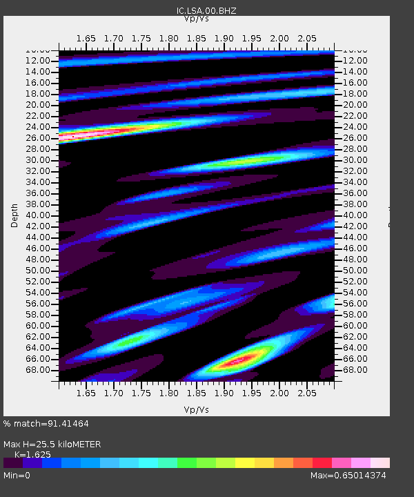
| Estimated Moho Depth: |
25.5 km |
| Estimated Crust Vp/Vs: |
1.62 |
| Assumed Crust Vp: |
6.514 km/s |
| Estimated Crust Vs: |
4.009 km/s |
| Estimated Crust Poisson's Ratio: |
0.20 |
|
| Radial Match: |
91.41464 % |
| Radial Bump: |
400 |
| Transverse Match: |
72.60381 % |
| Transverse Bump: |
400 |
| SOD ConfigId: |
343573 |
| Insert Time: |
2011-03-05 07:51:51.565 +0000 |
| GWidth: |
2.5 |
| Max Bumps: |
400 |
| Tol: |
0.001 |
|
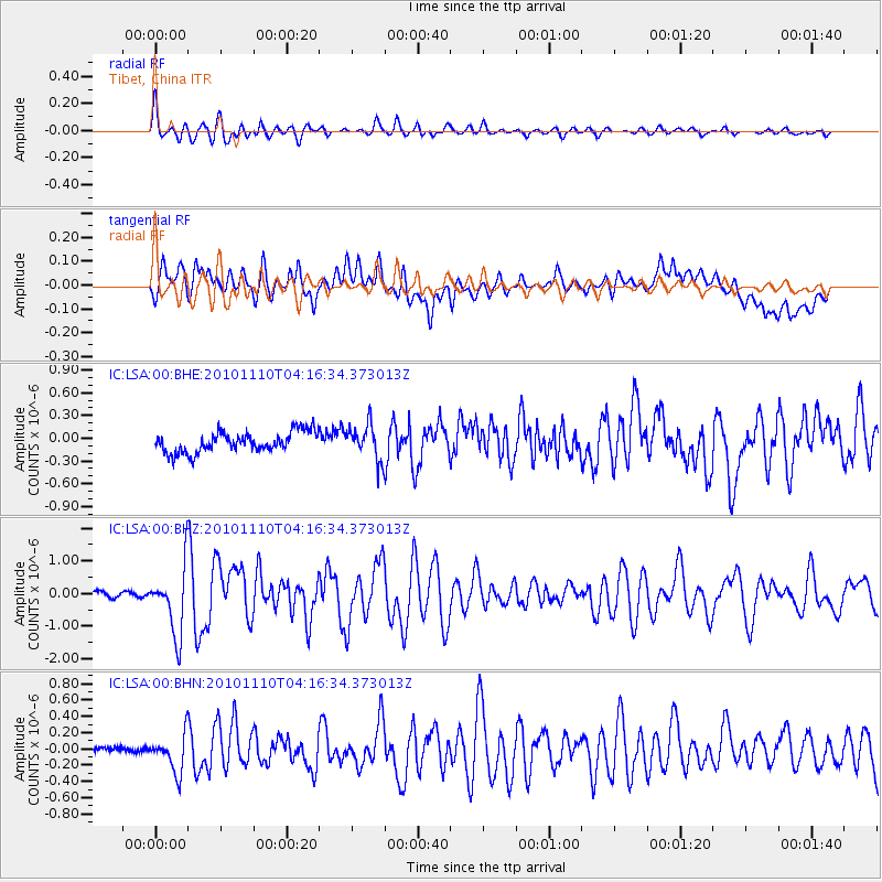
Signal To Noise
| Channel | StoN | STA | LTA |
| IC:LSA:00:BHZ:20101110T04:16:34.373013Z | 13.642057 | 1.0371949E-6 | 7.602922E-8 |
| IC:LSA:00:BHN:20101110T04:16:34.373013Z | 7.401928 | 2.3062054E-7 | 3.1156823E-8 |
| IC:LSA:00:BHE:20101110T04:16:34.373013Z | 1.6970724 | 2.2963931E-7 | 1.3531498E-7 |
| Arrivals |
| Ps | 2.5 SECOND |
| PpPs | 9.9 SECOND |
| PsPs/PpSs | 12 SECOND |


