You are here: Home > Network List > C0 - Colorado Geological Survey Seismic Network Stations List
> Station CHIL CSU-CHILL Radar > Earthquake Result Viewer
CHIL CSU-CHILL Radar - Earthquake Result Viewer
| Earthquake location: |
Kermadec Islands, New Zealand |
| Earthquake latitude/longitude: |
-30.0/-177.9 |
| Earthquake time(UTC): |
2023/04/24 (114) 00:41:54 GMT |
| Earthquake Depth: |
34 km |
| Earthquake Magnitude: |
7.3 mww |
| Earthquake Catalog/Contributor: |
NEIC PDE/us |
|
| Network: |
C0 Colorado Geological Survey Seismic Network |
| Station: |
CHIL CSU-CHILL Radar |
| Lat/Lon: |
40.45 N/104.64 W |
| Elevation: |
1424 m |
|
| Distance: |
97.5 deg |
| Az: |
47.491 deg |
| Baz: |
236.901 deg |
| Ray Param: |
0.04017144 |
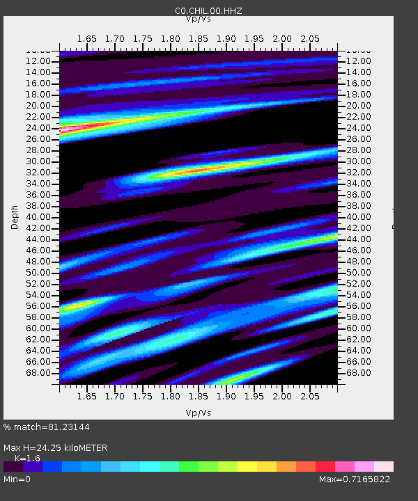
| Estimated Moho Depth: |
24.25 km |
| Estimated Crust Vp/Vs: |
1.60 |
| Assumed Crust Vp: |
6.306 km/s |
| Estimated Crust Vs: |
3.941 km/s |
| Estimated Crust Poisson's Ratio: |
0.18 |
|
| Radial Match: |
81.23144 % |
| Radial Bump: |
400 |
| Transverse Match: |
61.476456 % |
| Transverse Bump: |
400 |
| SOD ConfigId: |
34243671 |
| Insert Time: |
2024-05-03 21:11:45.140 +0000 |
| GWidth: |
2.5 |
| Max Bumps: |
400 |
| Tol: |
0.001 |
|

Signal To Noise
| Channel | StoN | STA | LTA |
| C0:CHIL:00:HHZ:20230424T00:54:52.944986Z | 8.810811 | 1.4114217E-6 | 1.6019204E-7 |
| C0:CHIL:00:HHN:20230424T00:54:52.944986Z | 1.1678884 | 3.086458E-7 | 2.642768E-7 |
| C0:CHIL:00:HHE:20230424T00:54:52.944986Z | 1.9368867 | 3.7629323E-7 | 1.9427736E-7 |
| Arrivals |
| Ps | 2.4 SECOND |
| PpPs | 9.8 SECOND |
| PsPs/PpSs | 12 SECOND |


