You are here: Home > Network List > AU - Australian Seismological Centre Stations List
> Station KIM07 GSWA station > Earthquake Result Viewer
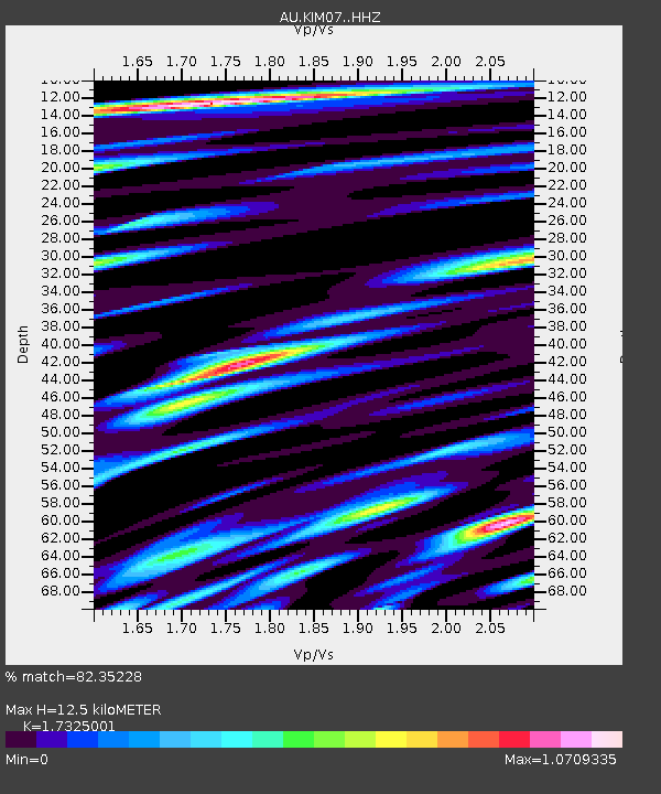
KIM07 GSWA station - Earthquake Result Viewer
| Earthquake location: |
South Of Fiji Islands |
| Earthquake latitude/longitude: |
-25.1/178.5 |
| Earthquake time(UTC): |
2023/04/28 (118) 03:13:43 GMT |
| Earthquake Depth: |
577 km |
| Earthquake Magnitude: |
6.2 mb |
| Earthquake Catalog/Contributor: |
NEIC PDE/us |
|
| Network: |
AU Australian Seismological Centre |
| Station: |
KIM07 GSWA station |
| Lat/Lon: |
17.99 S/123.16 E |
| Elevation: |
101 m |
|
| Distance: |
51.6 deg |
| Az: |
266.368 deg |
| Baz: |
108.072 deg |
| Ray Param: |
0.06466956 |
| Estimated Moho Depth: |
12.5 km |
| Estimated Crust Vp/Vs: |
1.73 |
| Assumed Crust Vp: |
6.159 km/s |
| Estimated Crust Vs: |
3.555 km/s |
| Estimated Crust Poisson's Ratio: |
0.25 |
|
| Radial Match: |
82.35228 % |
| Radial Bump: |
400 |
| Transverse Match: |
72.23227 % |
| Transverse Bump: |
400 |
| SOD ConfigId: |
34243671 |
| Insert Time: |
2024-05-03 22:53:49.274 +0000 |
| GWidth: |
2.5 |
| Max Bumps: |
400 |
| Tol: |
0.001 |
|

Signal To Noise
| Channel | StoN | STA | LTA |
| AU:KIM07: :HHZ:20230428T03:21:27.329997Z | 26.087408 | 1.083996E-5 | 4.155246E-7 |
| AU:KIM07: :HHN:20230428T03:21:27.329997Z | 17.847603 | 6.8947033E-6 | 3.8630978E-7 |
| AU:KIM07: :HHE:20230428T03:21:27.329997Z | 18.86288 | 9.4238685E-6 | 4.9959857E-7 |
| Arrivals |
| Ps | 1.6 SECOND |
| PpPs | 5.3 SECOND |
| PsPs/PpSs | 6.8 SECOND |


