You are here: Home > Network List > AK - Alaska Regional Network Stations List
> Station SII Sitkinak Island Coast Guard > Earthquake Result Viewer
SII Sitkinak Island Coast Guard - Earthquake Result Viewer
| Earthquake location: |
Southwestern Ryukyu Isl., Japan |
| Earthquake latitude/longitude: |
24.5/123.5 |
| Earthquake time(UTC): |
2014/01/08 (008) 18:15:11 GMT |
| Earthquake Depth: |
73 km |
| Earthquake Magnitude: |
5.3 MW |
| Earthquake Catalog/Contributor: |
ISC/ISC |
|
| Network: |
AK Alaska Regional Network |
| Station: |
SII Sitkinak Island Coast Guard |
| Lat/Lon: |
56.56 N/154.18 W |
| Elevation: |
465 m |
|
| Distance: |
65.7 deg |
| Az: |
37.011 deg |
| Baz: |
278.064 deg |
| Ray Param: |
0.05790829 |
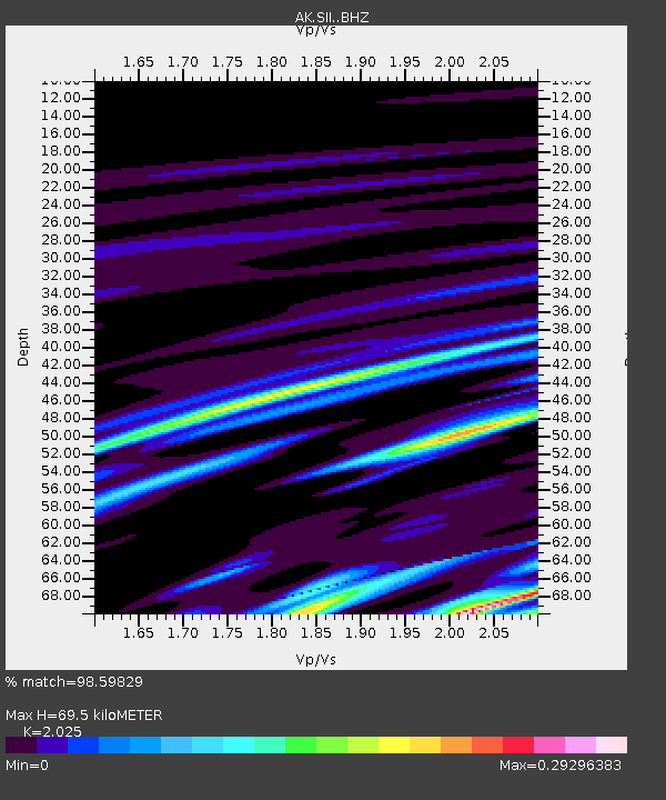
| Estimated Moho Depth: |
69.5 km |
| Estimated Crust Vp/Vs: |
2.03 |
| Assumed Crust Vp: |
6.24 km/s |
| Estimated Crust Vs: |
3.081 km/s |
| Estimated Crust Poisson's Ratio: |
0.34 |
|
| Radial Match: |
98.59829 % |
| Radial Bump: |
95 |
| Transverse Match: |
83.57798 % |
| Transverse Bump: |
400 |
| SOD ConfigId: |
3390531 |
| Insert Time: |
2019-04-09 22:41:04.434 +0000 |
| GWidth: |
2.5 |
| Max Bumps: |
400 |
| Tol: |
0.001 |
|

Signal To Noise
| Channel | StoN | STA | LTA |
| AK:SII: :BHZ:20140108T18:25:17.687976Z | 1.2687443 | 6.123392E-7 | 4.82634E-7 |
| AK:SII: :BHN:20140108T18:25:17.687976Z | 1.2972021 | 8.857468E-8 | 6.8281324E-8 |
| AK:SII: :BHE:20140108T18:25:17.687976Z | 1.3533738 | 1.2181474E-6 | 9.00082E-7 |
| Arrivals |
| Ps | 12 SECOND |
| PpPs | 33 SECOND |
| PsPs/PpSs | 44 SECOND |


