You are here: Home > Network List > YX16 - Raton Basin UNM Broadband Network Stations List
> Station UNM1 NE Corner of NM Stations > Earthquake Result Viewer
UNM1 NE Corner of NM Stations - Earthquake Result Viewer
| Earthquake location: |
Near West Coast Of Honshu, Japan |
| Earthquake latitude/longitude: |
37.5/137.3 |
| Earthquake time(UTC): |
2023/05/05 (125) 05:42:04 GMT |
| Earthquake Depth: |
8.7 km |
| Earthquake Magnitude: |
6.2 mww |
| Earthquake Catalog/Contributor: |
NEIC PDE/us |
|
| Network: |
YX Raton Basin UNM Broadband Network |
| Station: |
UNM1 NE Corner of NM Stations |
| Lat/Lon: |
36.96 N/104.82 W |
| Elevation: |
2470 m |
|
| Distance: |
86.2 deg |
| Az: |
45.199 deg |
| Baz: |
315.237 deg |
| Ray Param: |
0.04419883 |
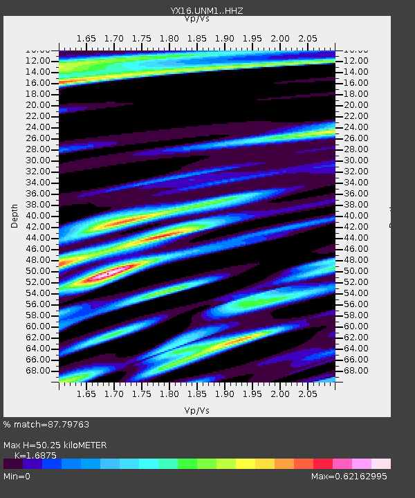
| Estimated Moho Depth: |
50.25 km |
| Estimated Crust Vp/Vs: |
1.69 |
| Assumed Crust Vp: |
6.316 km/s |
| Estimated Crust Vs: |
3.743 km/s |
| Estimated Crust Poisson's Ratio: |
0.23 |
|
| Radial Match: |
87.79763 % |
| Radial Bump: |
400 |
| Transverse Match: |
75.18494 % |
| Transverse Bump: |
400 |
| SOD ConfigId: |
34243671 |
| Insert Time: |
2024-05-04 01:51:02.272 +0000 |
| GWidth: |
2.5 |
| Max Bumps: |
400 |
| Tol: |
0.001 |
|

Signal To Noise
| Channel | StoN | STA | LTA |
| YX:UNM1: :HHZ:20230505T05:54:14.489998Z | 13.862697 | 1.944899E-6 | 1.4029729E-7 |
| YX:UNM1: :HHN:20230505T05:54:14.489998Z | 2.5171869 | 5.157855E-7 | 2.0490553E-7 |
| YX:UNM1: :HHE:20230505T05:54:14.489998Z | 0.6619834 | 2.3992084E-7 | 3.624273E-7 |
| Arrivals |
| Ps | 5.6 SECOND |
| PpPs | 21 SECOND |
| PsPs/PpSs | 26 SECOND |


