You are here: Home > Network List > TX - Texas Seismological Network Stations List
> Station FW07 Weatherford > Earthquake Result Viewer
FW07 Weatherford - Earthquake Result Viewer
| Earthquake location: |
Tonga Islands |
| Earthquake latitude/longitude: |
-15.6/-174.6 |
| Earthquake time(UTC): |
2023/05/10 (130) 16:02:00 GMT |
| Earthquake Depth: |
210 km |
| Earthquake Magnitude: |
7.6 mww |
| Earthquake Catalog/Contributor: |
NEIC PDE/us |
|
| Network: |
TX Texas Seismological Network |
| Station: |
FW07 Weatherford |
| Lat/Lon: |
32.70 N/97.79 W |
| Elevation: |
311 m |
|
| Distance: |
87.6 deg |
| Az: |
55.249 deg |
| Baz: |
249.894 deg |
| Ray Param: |
0.0426996 |
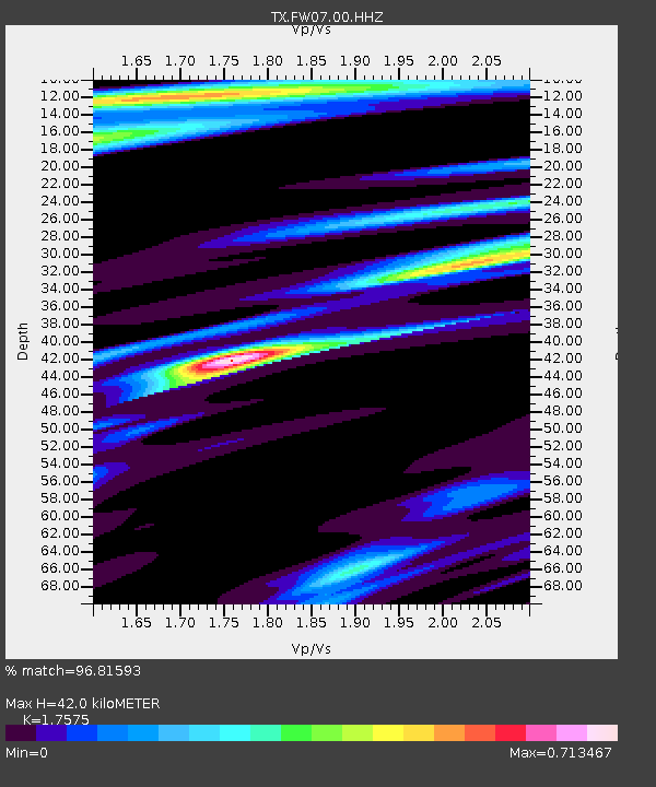
| Estimated Moho Depth: |
42.0 km |
| Estimated Crust Vp/Vs: |
1.76 |
| Assumed Crust Vp: |
6.38 km/s |
| Estimated Crust Vs: |
3.63 km/s |
| Estimated Crust Poisson's Ratio: |
0.26 |
|
| Radial Match: |
96.81593 % |
| Radial Bump: |
263 |
| Transverse Match: |
84.85347 % |
| Transverse Bump: |
400 |
| SOD ConfigId: |
34243671 |
| Insert Time: |
2024-05-04 03:37:56.536 +0000 |
| GWidth: |
2.5 |
| Max Bumps: |
400 |
| Tol: |
0.001 |
|

Signal To Noise
| Channel | StoN | STA | LTA |
| TX:FW07:00:HHZ:20230510T16:13:53.076Z | 22.260956 | 4.409402E-6 | 1.9807786E-7 |
| TX:FW07:00:HHN:20230510T16:13:53.076Z | 2.8669615 | 9.0370196E-7 | 3.1521247E-7 |
| TX:FW07:00:HHE:20230510T16:13:53.076Z | 2.8694618 | 9.659203E-7 | 3.3662076E-7 |
| Arrivals |
| Ps | 5.1 SECOND |
| PpPs | 18 SECOND |
| PsPs/PpSs | 23 SECOND |


