You are here: Home > Network List > TX - Texas Seismological Network Stations List
> Station PB13 Reeves - Culberson Border > Earthquake Result Viewer
PB13 Reeves - Culberson Border - Earthquake Result Viewer
| Earthquake location: |
Tonga Islands |
| Earthquake latitude/longitude: |
-15.6/-174.6 |
| Earthquake time(UTC): |
2023/05/10 (130) 16:02:00 GMT |
| Earthquake Depth: |
210 km |
| Earthquake Magnitude: |
7.6 mww |
| Earthquake Catalog/Contributor: |
NEIC PDE/us |
|
| Network: |
TX Texas Seismological Network |
| Station: |
PB13 Reeves - Culberson Border |
| Lat/Lon: |
31.55 N/103.85 W |
| Elevation: |
956 m |
|
| Distance: |
82.4 deg |
| Az: |
54.404 deg |
| Baz: |
246.611 deg |
| Ray Param: |
0.04638882 |
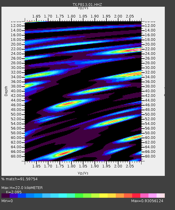
| Estimated Moho Depth: |
22.0 km |
| Estimated Crust Vp/Vs: |
2.10 |
| Assumed Crust Vp: |
6.121 km/s |
| Estimated Crust Vs: |
2.921 km/s |
| Estimated Crust Poisson's Ratio: |
0.35 |
|
| Radial Match: |
91.59754 % |
| Radial Bump: |
400 |
| Transverse Match: |
80.971886 % |
| Transverse Bump: |
400 |
| SOD ConfigId: |
34243671 |
| Insert Time: |
2024-05-04 03:38:14.926 +0000 |
| GWidth: |
2.5 |
| Max Bumps: |
400 |
| Tol: |
0.001 |
|

Signal To Noise
| Channel | StoN | STA | LTA |
| TX:PB13:01:HHZ:20230510T16:13:27.349987Z | 10.829725 | 3.2337127E-6 | 2.98596E-7 |
| TX:PB13:01:HHN:20230510T16:13:27.349987Z | 0.99858385 | 3.8447172E-7 | 3.8501693E-7 |
| TX:PB13:01:HHE:20230510T16:13:27.349987Z | 4.6973825 | 1.2903852E-6 | 2.74703E-7 |
| Arrivals |
| Ps | 4.0 SECOND |
| PpPs | 11 SECOND |
| PsPs/PpSs | 15 SECOND |


