You are here: Home > Network List > TX - Texas Seismological Network Stations List
> Station PB30 Pecos City Water South > Earthquake Result Viewer
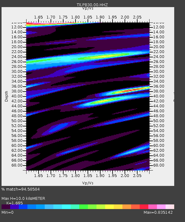
PB30 Pecos City Water South - Earthquake Result Viewer
| Earthquake location: |
Tonga Islands |
| Earthquake latitude/longitude: |
-15.6/-174.6 |
| Earthquake time(UTC): |
2023/05/10 (130) 16:02:00 GMT |
| Earthquake Depth: |
210 km |
| Earthquake Magnitude: |
7.6 mww |
| Earthquake Catalog/Contributor: |
NEIC PDE/us |
|
| Network: |
TX Texas Seismological Network |
| Station: |
PB30 Pecos City Water South |
| Lat/Lon: |
31.28 N/103.32 W |
| Elevation: |
829 m |
|
| Distance: |
82.7 deg |
| Az: |
54.834 deg |
| Baz: |
246.938 deg |
| Ray Param: |
0.046179164 |
| Estimated Moho Depth: |
10.0 km |
| Estimated Crust Vp/Vs: |
1.70 |
| Assumed Crust Vp: |
6.121 km/s |
| Estimated Crust Vs: |
3.611 km/s |
| Estimated Crust Poisson's Ratio: |
0.23 |
|
| Radial Match: |
94.58584 % |
| Radial Bump: |
400 |
| Transverse Match: |
84.45013 % |
| Transverse Bump: |
400 |
| SOD ConfigId: |
34243671 |
| Insert Time: |
2024-05-04 03:38:26.222 +0000 |
| GWidth: |
2.5 |
| Max Bumps: |
400 |
| Tol: |
0.001 |
|

Signal To Noise
| Channel | StoN | STA | LTA |
| TX:PB30:00:HHZ:20230510T16:13:28.896984Z | 9.785633 | 2.9027447E-6 | 2.9663332E-7 |
| TX:PB30:00:HHN:20230510T16:13:28.896984Z | 1.134755 | 3.7626535E-7 | 3.315829E-7 |
| TX:PB30:00:HHE:20230510T16:13:28.896984Z | 1.3969313 | 2.883617E-7 | 2.0642511E-7 |
| Arrivals |
| Ps | 1.2 SECOND |
| PpPs | 4.3 SECOND |
| PsPs/PpSs | 5.5 SECOND |


