You are here: Home > Network List > TX - Texas Seismological Network Stations List
> Station PECS Pecos > Earthquake Result Viewer
PECS Pecos - Earthquake Result Viewer
| Earthquake location: |
Tonga Islands |
| Earthquake latitude/longitude: |
-15.6/-174.6 |
| Earthquake time(UTC): |
2023/05/10 (130) 16:02:00 GMT |
| Earthquake Depth: |
210 km |
| Earthquake Magnitude: |
7.6 mww |
| Earthquake Catalog/Contributor: |
NEIC PDE/us |
|
| Network: |
TX Texas Seismological Network |
| Station: |
PECS Pecos |
| Lat/Lon: |
31.37 N/103.87 W |
| Elevation: |
914 m |
|
| Distance: |
82.3 deg |
| Az: |
54.566 deg |
| Baz: |
246.622 deg |
| Ray Param: |
0.04645161 |
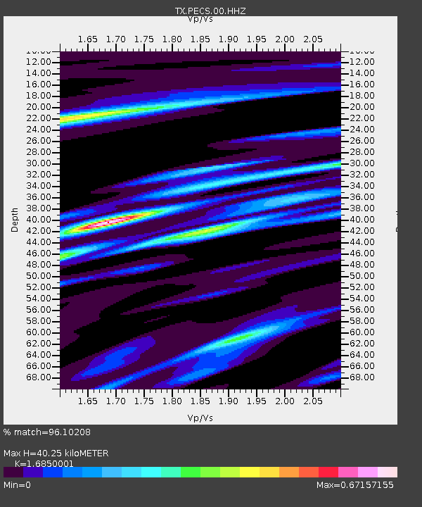
| Estimated Moho Depth: |
40.25 km |
| Estimated Crust Vp/Vs: |
1.69 |
| Assumed Crust Vp: |
6.121 km/s |
| Estimated Crust Vs: |
3.632 km/s |
| Estimated Crust Poisson's Ratio: |
0.23 |
|
| Radial Match: |
96.10208 % |
| Radial Bump: |
332 |
| Transverse Match: |
86.88018 % |
| Transverse Bump: |
400 |
| SOD ConfigId: |
34243671 |
| Insert Time: |
2024-05-04 03:38:31.590 +0000 |
| GWidth: |
2.5 |
| Max Bumps: |
400 |
| Tol: |
0.001 |
|

Signal To Noise
| Channel | StoN | STA | LTA |
| TX:PECS:00:HHZ:20230510T16:13:26.880016Z | 7.466053 | 3.5232947E-6 | 4.7190863E-7 |
| TX:PECS:00:HH1:20230510T16:13:26.880016Z | 2.2318556 | 1.0526102E-6 | 4.7163002E-7 |
| TX:PECS:00:HH2:20230510T16:13:26.880016Z | 2.1703684 | 6.424273E-7 | 2.959992E-7 |
| Arrivals |
| Ps | 4.6 SECOND |
| PpPs | 17 SECOND |
| PsPs/PpSs | 22 SECOND |


