You are here: Home > Network List > GT - Global Telemetered Seismograph Network (USAF/USGS) Stations List
> Station LPAZ La Paz , Bolivia > Earthquake Result Viewer
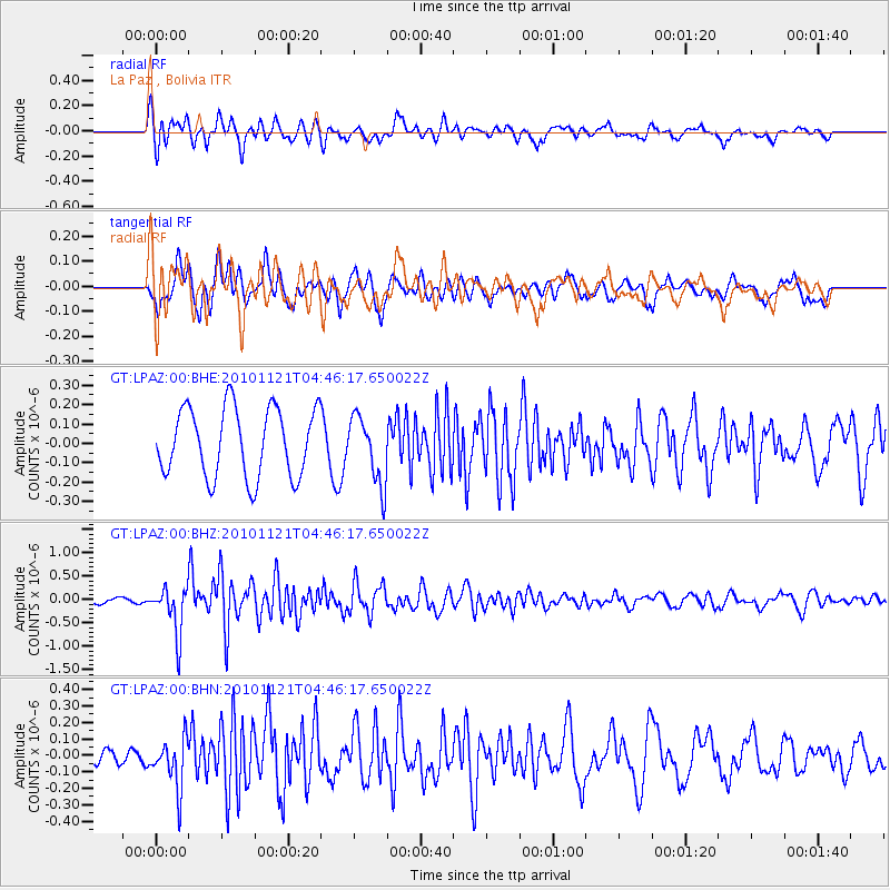
LPAZ La Paz , Bolivia - Earthquake Result Viewer
*The percent match for this event was below the threshold and hence no stack was calculated.
| Earthquake location: |
Pacific-Antarctic Ridge |
| Earthquake latitude/longitude: |
-55.0/-131.5 |
| Earthquake time(UTC): |
2010/11/21 (325) 04:36:31 GMT |
| Earthquake Depth: |
10 km |
| Earthquake Magnitude: |
5.7 MB, 5.8 MS, 6.0 MW, 5.9 MW |
| Earthquake Catalog/Contributor: |
WHDF/NEIC |
|
| Network: |
GT Global Telemetered Seismograph Network (USAF/USGS) |
| Station: |
LPAZ La Paz , Bolivia |
| Lat/Lon: |
16.17 S/68.08 W |
| Elevation: |
4817 m |
|
| Distance: |
61.7 deg |
| Az: |
77.41 deg |
| Baz: |
215.849 deg |
| Ray Param: |
$rayparam |
*The percent match for this event was below the threshold and hence was not used in the summary stack. |
|
| Radial Match: |
76.19045 % |
| Radial Bump: |
400 |
| Transverse Match: |
57.602036 % |
| Transverse Bump: |
400 |
| SOD ConfigId: |
343951 |
| Insert Time: |
2011-05-23 21:19:09.887 +0000 |
| GWidth: |
2.5 |
| Max Bumps: |
400 |
| Tol: |
0.001 |
|
Signal To Noise
| Channel | StoN | STA | LTA |
| GT:LPAZ:00:BHZ:20101121T04:46:17.650022Z | 4.3344893 | 5.0892504E-7 | 1.17412924E-7 |
| GT:LPAZ:00:BHN:20101121T04:46:17.650022Z | 2.0682783 | 1.502008E-7 | 7.262118E-8 |
| GT:LPAZ:00:BHE:20101121T04:46:17.650022Z | 0.9735051 | 1.7403035E-7 | 1.7876675E-7 |
| Arrivals |
| Ps | |
| PpPs | |
| PsPs/PpSs | |


