You are here: Home > Network List > YT07 - POLENET Stations List
> Station WAIS WAIS > Earthquake Result Viewer
WAIS WAIS - Earthquake Result Viewer
| Earthquake location: |
Southeast Of Loyalty Islands |
| Earthquake latitude/longitude: |
-23.2/170.8 |
| Earthquake time(UTC): |
2023/05/19 (139) 03:06:24 GMT |
| Earthquake Depth: |
38 km |
| Earthquake Magnitude: |
5.9 mb |
| Earthquake Catalog/Contributor: |
NEIC PDE/us |
|
| Network: |
YT POLENET |
| Station: |
WAIS WAIS |
| Lat/Lon: |
79.42 S/111.78 W |
| Elevation: |
1800 m |
|
| Distance: |
65.0 deg |
| Az: |
168.52 deg |
| Baz: |
277.858 deg |
| Ray Param: |
0.058472738 |
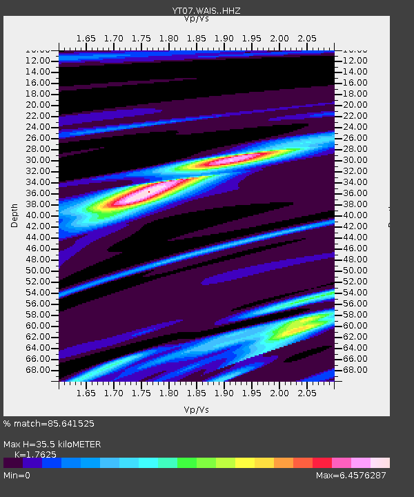
| Estimated Moho Depth: |
35.5 km |
| Estimated Crust Vp/Vs: |
1.76 |
| Assumed Crust Vp: |
5.833 km/s |
| Estimated Crust Vs: |
3.31 km/s |
| Estimated Crust Poisson's Ratio: |
0.26 |
|
| Radial Match: |
85.641525 % |
| Radial Bump: |
328 |
| Transverse Match: |
53.267315 % |
| Transverse Bump: |
400 |
| SOD ConfigId: |
34243671 |
| Insert Time: |
2024-05-04 06:25:32.178 +0000 |
| GWidth: |
2.5 |
| Max Bumps: |
400 |
| Tol: |
0.001 |
|

Signal To Noise
| Channel | StoN | STA | LTA |
| YT:WAIS: :HHZ:20230519T03:16:30.658982Z | 2.6344893 | 3.967605E-5 | 1.5060244E-5 |
| YT:WAIS: :HHN:20230519T03:16:30.658982Z | 0.562818 | 1.4072705E-5 | 2.5004008E-5 |
| YT:WAIS: :HHE:20230519T03:16:30.658982Z | 0.9461104 | 3.0437839E-5 | 3.217155E-5 |
| Arrivals |
| Ps | 4.8 SECOND |
| PpPs | 16 SECOND |
| PsPs/PpSs | 21 SECOND |


