You are here: Home > Network List > G - GEOSCOPE Stations List
> Station RER Riviere de l'Est, La Reunion (Indian Ocean) > Earthquake Result Viewer
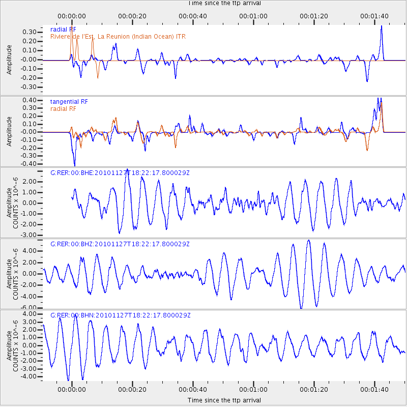
RER Riviere de l'Est, La Reunion (Indian Ocean) - Earthquake Result Viewer
*The percent match for this event was below the threshold and hence no stack was calculated.
| Earthquake location: |
North Of Halmahera, Indonesia |
| Earthquake latitude/longitude: |
3.9/128.1 |
| Earthquake time(UTC): |
2010/11/27 (331) 18:11:13 GMT |
| Earthquake Depth: |
59 km |
| Earthquake Magnitude: |
5.9 MB, 5.7 MW, 5.6 MW |
| Earthquake Catalog/Contributor: |
WHDF/NEIC |
|
| Network: |
G GEOSCOPE |
| Station: |
RER Riviere de l'Est, La Reunion (Indian Ocean) |
| Lat/Lon: |
21.16 S/55.75 E |
| Elevation: |
834 m |
|
| Distance: |
75.0 deg |
| Az: |
247.027 deg |
| Baz: |
79.794 deg |
| Ray Param: |
$rayparam |
*The percent match for this event was below the threshold and hence was not used in the summary stack. |
|
| Radial Match: |
44.57621 % |
| Radial Bump: |
400 |
| Transverse Match: |
41.167667 % |
| Transverse Bump: |
400 |
| SOD ConfigId: |
343951 |
| Insert Time: |
2011-05-23 22:59:45.016 +0000 |
| GWidth: |
2.5 |
| Max Bumps: |
400 |
| Tol: |
0.001 |
|
Signal To Noise
| Channel | StoN | STA | LTA |
| G:RER:00:BHZ:20101127T18:22:17.800029Z | 1.5213431 | 1.7258006E-6 | 1.1343927E-6 |
| G:RER:00:BHN:20101127T18:22:17.800029Z | 1.6434386 | 2.757391E-6 | 1.6778182E-6 |
| G:RER:00:BHE:20101127T18:22:17.800029Z | 0.922876 | 1.2735964E-6 | 1.3800297E-6 |
| Arrivals |
| Ps | |
| PpPs | |
| PsPs/PpSs | |


