You are here: Home > Network List > IC - New China Digital Seismograph Network Stations List
> Station LSA Tibet, China > Earthquake Result Viewer
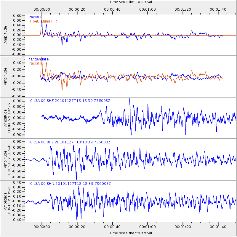
LSA Tibet, China - Earthquake Result Viewer
*The percent match for this event was below the threshold and hence no stack was calculated.
| Earthquake location: |
North Of Halmahera, Indonesia |
| Earthquake latitude/longitude: |
3.9/128.1 |
| Earthquake time(UTC): |
2010/11/27 (331) 18:11:13 GMT |
| Earthquake Depth: |
59 km |
| Earthquake Magnitude: |
5.9 MB, 5.7 MW, 5.6 MW |
| Earthquake Catalog/Contributor: |
WHDF/NEIC |
|
| Network: |
IC New China Digital Seismograph Network |
| Station: |
LSA Tibet, China |
| Lat/Lon: |
29.70 N/91.13 E |
| Elevation: |
3660 m |
|
| Distance: |
43.4 deg |
| Az: |
310.421 deg |
| Baz: |
119.183 deg |
| Ray Param: |
$rayparam |
*The percent match for this event was below the threshold and hence was not used in the summary stack. |
|
| Radial Match: |
79.67585 % |
| Radial Bump: |
400 |
| Transverse Match: |
64.871 % |
| Transverse Bump: |
400 |
| SOD ConfigId: |
343951 |
| Insert Time: |
2011-05-23 23:01:28.071 +0000 |
| GWidth: |
2.5 |
| Max Bumps: |
400 |
| Tol: |
0.001 |
|
Signal To Noise
| Channel | StoN | STA | LTA |
| IC:LSA:00:BHZ:20101127T18:18:39.736003Z | 2.5686538 | 1.6807441E-7 | 6.543288E-8 |
| IC:LSA:00:BHN:20101127T18:18:39.736003Z | 1.8920661 | 3.633354E-8 | 1.9203101E-8 |
| IC:LSA:00:BHE:20101127T18:18:39.736003Z | 2.4142258 | 1.728534E-7 | 7.159786E-8 |
| Arrivals |
| Ps | |
| PpPs | |
| PsPs/PpSs | |


