You are here: Home > Network List > KN - Kyrgyz Seismic Telemetry Network Stations List
> Station TKM2 KN.TKM2 > Earthquake Result Viewer
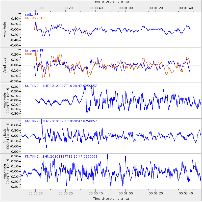
TKM2 KN.TKM2 - Earthquake Result Viewer
*The percent match for this event was below the threshold and hence no stack was calculated.
| Earthquake location: |
North Of Halmahera, Indonesia |
| Earthquake latitude/longitude: |
3.9/128.1 |
| Earthquake time(UTC): |
2010/11/27 (331) 18:11:13 GMT |
| Earthquake Depth: |
59 km |
| Earthquake Magnitude: |
5.9 MB, 5.7 MW, 5.6 MW |
| Earthquake Catalog/Contributor: |
WHDF/NEIC |
|
| Network: |
KN Kyrgyz Seismic Telemetry Network |
| Station: |
TKM2 KN.TKM2 |
| Lat/Lon: |
42.92 N/75.60 E |
| Elevation: |
2020 m |
|
| Distance: |
60.5 deg |
| Az: |
318.003 deg |
| Baz: |
114.656 deg |
| Ray Param: |
$rayparam |
*The percent match for this event was below the threshold and hence was not used in the summary stack. |
|
| Radial Match: |
57.31797 % |
| Radial Bump: |
400 |
| Transverse Match: |
55.87035 % |
| Transverse Bump: |
400 |
| SOD ConfigId: |
343951 |
| Insert Time: |
2011-05-23 23:08:33.576 +0000 |
| GWidth: |
2.5 |
| Max Bumps: |
400 |
| Tol: |
0.001 |
|
Signal To Noise
| Channel | StoN | STA | LTA |
| KN:TKM2: :BHZ:20101127T18:20:47.025005Z | 5.527056 | 3.0255956E-7 | 5.4741534E-8 |
| KN:TKM2: :BHN:20101127T18:20:47.025005Z | 1.0325177 | 7.4239615E-8 | 7.1901546E-8 |
| KN:TKM2: :BHE:20101127T18:20:47.025005Z | 5.060535 | 1.959516E-7 | 3.872152E-8 |
| Arrivals |
| Ps | |
| PpPs | |
| PsPs/PpSs | |


