You are here: Home > Network List > TX - Texas Seismological Network Stations List
> Station PB13 Reeves - Culberson Border > Earthquake Result Viewer
PB13 Reeves - Culberson Border - Earthquake Result Viewer
| Earthquake location: |
Hokkaido, Japan Region |
| Earthquake latitude/longitude: |
42.5/141.9 |
| Earthquake time(UTC): |
2023/06/11 (162) 09:54:45 GMT |
| Earthquake Depth: |
125 km |
| Earthquake Magnitude: |
6.2 mww |
| Earthquake Catalog/Contributor: |
NEIC PDE/us |
|
| Network: |
TX Texas Seismological Network |
| Station: |
PB13 Reeves - Culberson Border |
| Lat/Lon: |
31.55 N/103.85 W |
| Elevation: |
956 m |
|
| Distance: |
84.7 deg |
| Az: |
51.429 deg |
| Baz: |
317.392 deg |
| Ray Param: |
0.044993833 |
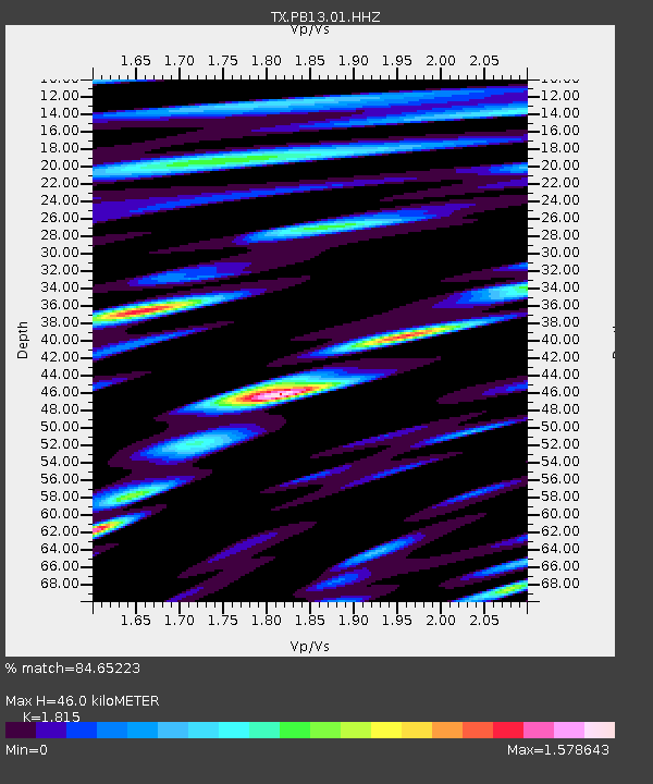
| Estimated Moho Depth: |
46.0 km |
| Estimated Crust Vp/Vs: |
1.82 |
| Assumed Crust Vp: |
6.121 km/s |
| Estimated Crust Vs: |
3.372 km/s |
| Estimated Crust Poisson's Ratio: |
0.28 |
|
| Radial Match: |
84.65223 % |
| Radial Bump: |
400 |
| Transverse Match: |
69.79814 % |
| Transverse Bump: |
400 |
| SOD ConfigId: |
34243671 |
| Insert Time: |
2024-05-04 15:58:33.869 +0000 |
| GWidth: |
2.5 |
| Max Bumps: |
400 |
| Tol: |
0.001 |
|

Signal To Noise
| Channel | StoN | STA | LTA |
| TX:PB13:01:HHZ:20230611T10:06:34.36997Z | 12.574445 | 9.329509E-7 | 7.4194205E-8 |
| TX:PB13:01:HHN:20230611T10:06:34.36997Z | 2.4578688 | 2.9120824E-7 | 1.1847998E-7 |
| TX:PB13:01:HHE:20230611T10:06:34.36997Z | 2.601614 | 2.9757712E-7 | 1.1438174E-7 |
| Arrivals |
| Ps | 6.3 SECOND |
| PpPs | 21 SECOND |
| PsPs/PpSs | 27 SECOND |


